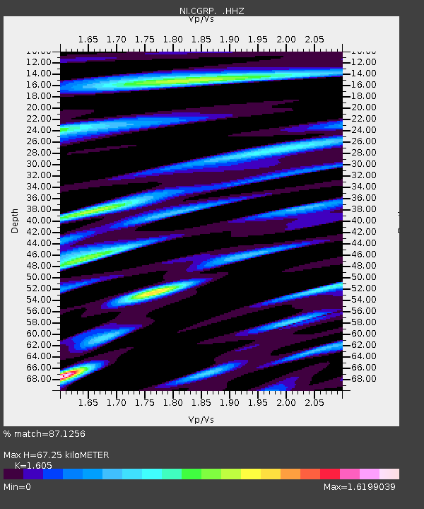
CGRP Cima Grappa - Earthquake Result Viewer

Earthquake location: Northern Sumatra, Indonesia
Earthquake latitude/longitude: 4.6/96.7
Earthquake time(UTC): 2013/07/02 (183) 07:37:02 GMT
Earthquake Depth: 13 km
Earthquake Magnitude: 6.1 MW, 5.9 MB, 6.1 MW, 6.2 MS
Earthquake Catalog/Contributor: NEIC PDE/NEIC PDE-W
Network: NI North-East Italy Broadband Network
Station: CGRP Cima Grappa
Lat/Lon: 45.88 N/11.80 E
Elevation: 1757 m
Distance: 83.1 deg
Az: 315.508 deg
Baz: 90.444 deg
Ray Param: 0.046414036
Estimated Moho Depth: 67.25 km
Estimated Crust Vp/Vs: 1.61
Assumed Crust Vp: 6.155 km/s
Estimated Crust Vs: 3.835 km/s
Estimated Crust Poisson's Ratio: 0.18
Radial Match: 87.1256 %
Radial Bump: 400
Transverse Match: 78.76349 %
Transverse Bump: 400
SOD ConfigId: 512894
Insert Time: 2013-09-15 11:03:02.969 +0000
GWidth: 2.5
Max Bumps: 400
Tol: 0.001

Signal To Noise

ChannelStoNSTALTA
NI:CGRP: :HHZ:20130702T07:48:56.51802Z11.6386096.7163484E-75.770749E-8
NI:CGRP: :HHN:20130702T07:48:56.51802Z1.8027311.2485967E-76.92614E-8
NI:CGRP: :HHE:20130702T07:48:56.51802Z3.92104863.4012197E-78.67426E-8
Arrivals
Ps6.8 SECOND
PpPs28 SECOND
PsPs/PpSs35 SECOND