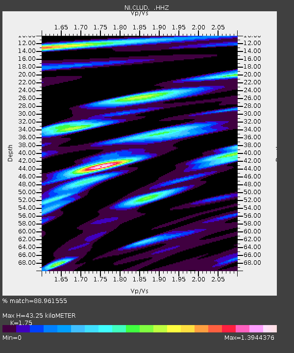
CLUD Cludinico - Earthquake Result Viewer

Earthquake location: Northern Sumatra, Indonesia
Earthquake latitude/longitude: 4.6/96.7
Earthquake time(UTC): 2013/07/02 (183) 07:37:02 GMT
Earthquake Depth: 13 km
Earthquake Magnitude: 6.1 MW, 5.9 MB, 6.1 MW, 6.2 MS
Earthquake Catalog/Contributor: NEIC PDE/NEIC PDE-W
Network: NI North-East Italy Broadband Network
Station: CLUD Cludinico
Lat/Lon: 46.46 N/12.88 E
Elevation: 635 m
Distance: 82.4 deg
Az: 316.1 deg
Baz: 91.293 deg
Ray Param: 0.046927698
Estimated Moho Depth: 43.25 km
Estimated Crust Vp/Vs: 1.75
Assumed Crust Vp: 6.35 km/s
Estimated Crust Vs: 3.629 km/s
Estimated Crust Poisson's Ratio: 0.26
Radial Match: 88.961555 %
Radial Bump: 400
Transverse Match: 81.3021 %
Transverse Bump: 400
SOD ConfigId: 512894
Insert Time: 2013-09-15 11:03:08.286 +0000
GWidth: 2.5
Max Bumps: 400
Tol: 0.001

Signal To Noise

ChannelStoNSTALTA
NI:CLUD: :HHZ:20130702T07:48:52.688003Z18.5944296.0896593E-73.2749913E-8
NI:CLUD: :HHN:20130702T07:48:52.688003Z2.06478211.0272216E-74.9749634E-8
NI:CLUD: :HHE:20130702T07:48:52.688003Z5.4915892.0394863E-73.7138363E-8
Arrivals
Ps5.2 SECOND
PpPs18 SECOND
PsPs/PpSs23 SECOND