You are here: Home > Network List > TJ - Tajikistan National Seismic Network Stations List
> Station GARM Garm, Tajikistan > Earthquake Result Viewer
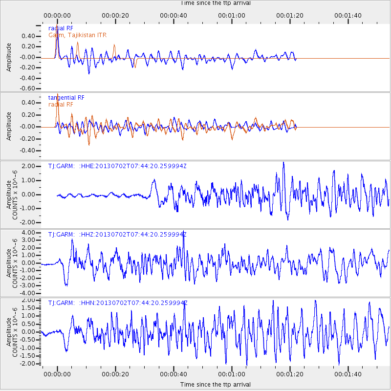
GARM Garm, Tajikistan - Earthquake Result Viewer
*The percent match for this event was below the threshold and hence no stack was calculated.
| Earthquake location: |
Northern Sumatra, Indonesia |
| Earthquake latitude/longitude: |
4.6/96.7 |
| Earthquake time(UTC): |
2013/07/02 (183) 07:37:02 GMT |
| Earthquake Depth: |
13 km |
| Earthquake Magnitude: |
6.1 MW, 5.9 MB, 6.1 MW, 6.2 MS |
| Earthquake Catalog/Contributor: |
NEIC PDE/NEIC PDE-W |
|
| Network: |
TJ Tajikistan National Seismic Network |
| Station: |
GARM Garm, Tajikistan |
| Lat/Lon: |
39.00 N/70.32 E |
| Elevation: |
1305 m |
|
| Distance: |
41.7 deg |
| Az: |
328.689 deg |
| Baz: |
138.335 deg |
| Ray Param: |
$rayparam |
*The percent match for this event was below the threshold and hence was not used in the summary stack. |
|
| Radial Match: |
73.44746 % |
| Radial Bump: |
400 |
| Transverse Match: |
70.568886 % |
| Transverse Bump: |
400 |
| SOD ConfigId: |
512894 |
| Insert Time: |
2013-09-15 11:04:25.470 +0000 |
| GWidth: |
2.5 |
| Max Bumps: |
400 |
| Tol: |
0.001 |
|
Signal To Noise
| Channel | StoN | STA | LTA |
| TJ:GARM: :HHZ:20130702T07:44:20.259994Z | 11.594091 | 1.3208496E-6 | 1.1392438E-7 |
| TJ:GARM: :HHN:20130702T07:44:20.259994Z | 9.396576 | 5.0217756E-7 | 5.344261E-8 |
| TJ:GARM: :HHE:20130702T07:44:20.259994Z | 5.891029 | 5.008834E-7 | 8.502478E-8 |
| Arrivals |
| Ps | |
| PpPs | |
| PsPs/PpSs | |


