You are here: Home > Network List > NE - New England Seismic Network Stations List
> Station EMMW Machias, ME, USA > Earthquake Result Viewer
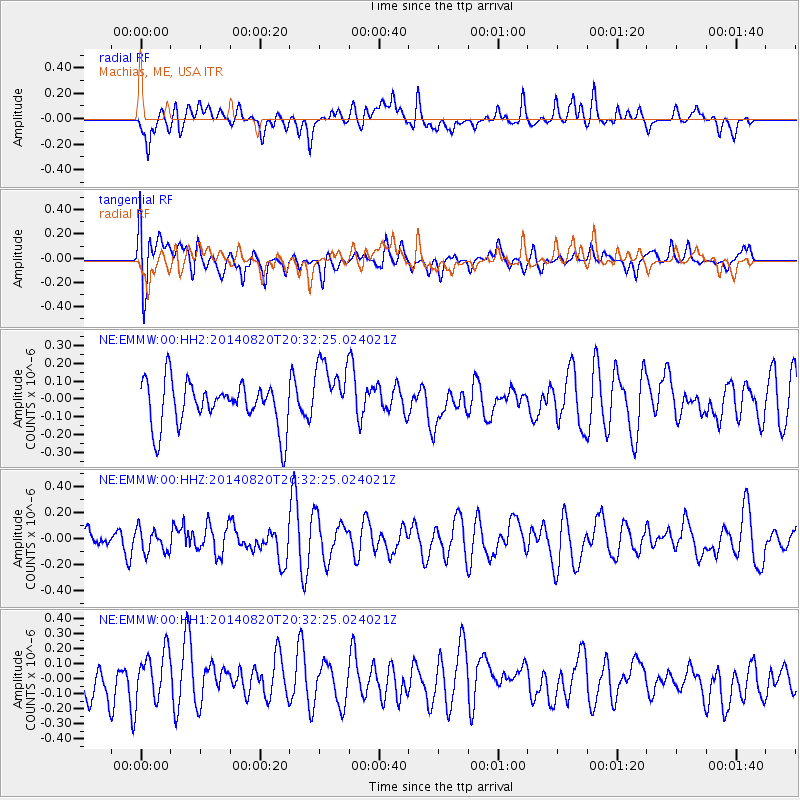
EMMW Machias, ME, USA - Earthquake Result Viewer
*The percent match for this event was below the threshold and hence no stack was calculated.
| Earthquake location: |
Rat Islands, Aleutian Islands |
| Earthquake latitude/longitude: |
52.5/175.4 |
| Earthquake time(UTC): |
2014/08/20 (232) 20:21:49 GMT |
| Earthquake Depth: |
10 km |
| Earthquake Magnitude: |
5.1 MW, 5.0 mb, 4.6 ML |
| Earthquake Catalog/Contributor: |
ISC/ISC |
|
| Network: |
NE New England Seismic Network |
| Station: |
EMMW Machias, ME, USA |
| Lat/Lon: |
44.71 N/67.46 W |
| Elevation: |
35 m |
|
| Distance: |
69.2 deg |
| Az: |
42.735 deg |
| Baz: |
324.392 deg |
| Ray Param: |
$rayparam |
*The percent match for this event was below the threshold and hence was not used in the summary stack. |
|
| Radial Match: |
46.87922 % |
| Radial Bump: |
400 |
| Transverse Match: |
55.840065 % |
| Transverse Bump: |
400 |
| SOD ConfigId: |
3390531 |
| Insert Time: |
2019-04-13 12:29:59.158 +0000 |
| GWidth: |
2.5 |
| Max Bumps: |
400 |
| Tol: |
0.001 |
|
Signal To Noise
| Channel | StoN | STA | LTA |
| NE:EMMW:00:HHZ:20140820T20:32:25.024021Z | 0.7858413 | 9.050365E-8 | 1.1516784E-7 |
| NE:EMMW:00:HH1:20140820T20:32:25.024021Z | 1.4743451 | 1.644757E-7 | 1.1155848E-7 |
| NE:EMMW:00:HH2:20140820T20:32:25.024021Z | 1.4397672 | 1.8180178E-7 | 1.2627164E-7 |
| Arrivals |
| Ps | |
| PpPs | |
| PsPs/PpSs | |


