You are here: Home > Network List > AK - Alaska Regional Network Stations List
> Station MDM Murphy Dome > Earthquake Result Viewer
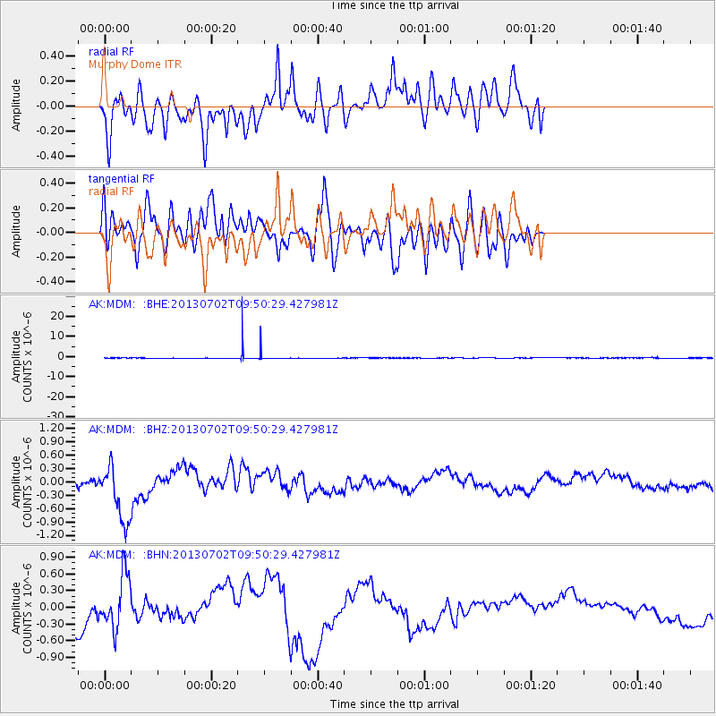
MDM Murphy Dome - Earthquake Result Viewer
*The percent match for this event was below the threshold and hence no stack was calculated.
| Earthquake location: |
Tonga Islands |
| Earthquake latitude/longitude: |
-15.7/-173.8 |
| Earthquake time(UTC): |
2013/07/02 (183) 09:38:41 GMT |
| Earthquake Depth: |
47 km |
| Earthquake Magnitude: |
5.5 MW, 5.6 MB |
| Earthquake Catalog/Contributor: |
NEIC PDE/NEIC PDE-W |
|
| Network: |
AK Alaska Regional Network |
| Station: |
MDM Murphy Dome |
| Lat/Lon: |
64.96 N/148.23 W |
| Elevation: |
634 m |
|
| Distance: |
82.8 deg |
| Az: |
10.673 deg |
| Baz: |
204.776 deg |
| Ray Param: |
$rayparam |
*The percent match for this event was below the threshold and hence was not used in the summary stack. |
|
| Radial Match: |
57.990833 % |
| Radial Bump: |
400 |
| Transverse Match: |
30.402246 % |
| Transverse Bump: |
400 |
| SOD ConfigId: |
512894 |
| Insert Time: |
2013-09-15 11:06:49.328 +0000 |
| GWidth: |
2.5 |
| Max Bumps: |
400 |
| Tol: |
0.001 |
|
Signal To Noise
| Channel | StoN | STA | LTA |
| AK:MDM: :BHZ:20130702T09:50:29.427981Z | 7.4295096 | 6.763874E-7 | 9.1040654E-8 |
| AK:MDM: :BHN:20130702T09:50:29.427981Z | 3.576153 | 4.8814485E-7 | 1.3649998E-7 |
| AK:MDM: :BHE:20130702T09:50:29.427981Z | 21.272644 | 1.7460032E-6 | 8.20774E-8 |
| Arrivals |
| Ps | |
| PpPs | |
| PsPs/PpSs | |


