You are here: Home > Network List > BK - Berkeley Digital Seismograph Network Stations List
> Station HUMO Hull Mountain, OR > Earthquake Result Viewer
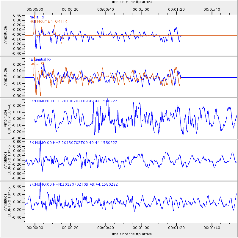
HUMO Hull Mountain, OR - Earthquake Result Viewer
*The percent match for this event was below the threshold and hence no stack was calculated.
| Earthquake location: |
Tonga Islands |
| Earthquake latitude/longitude: |
-15.7/-173.8 |
| Earthquake time(UTC): |
2013/07/02 (183) 09:38:41 GMT |
| Earthquake Depth: |
47 km |
| Earthquake Magnitude: |
5.5 MW, 5.6 MB |
| Earthquake Catalog/Contributor: |
NEIC PDE/NEIC PDE-W |
|
| Network: |
BK Berkeley Digital Seismograph Network |
| Station: |
HUMO Hull Mountain, OR |
| Lat/Lon: |
42.61 N/122.96 W |
| Elevation: |
555 m |
|
| Distance: |
74.5 deg |
| Az: |
36.449 deg |
| Baz: |
230.804 deg |
| Ray Param: |
$rayparam |
*The percent match for this event was below the threshold and hence was not used in the summary stack. |
|
| Radial Match: |
62.194595 % |
| Radial Bump: |
400 |
| Transverse Match: |
62.486816 % |
| Transverse Bump: |
400 |
| SOD ConfigId: |
512894 |
| Insert Time: |
2013-09-15 11:10:33.727 +0000 |
| GWidth: |
2.5 |
| Max Bumps: |
400 |
| Tol: |
0.001 |
|
Signal To Noise
| Channel | StoN | STA | LTA |
| BK:HUMO:00:HHZ:20130702T09:49:44.158022Z | 3.5268502 | 2.708938E-7 | 7.680899E-8 |
| BK:HUMO:00:HHN:20130702T09:49:44.158022Z | 2.176497 | 1.6126832E-7 | 7.4095354E-8 |
| BK:HUMO:00:HHE:20130702T09:49:44.158022Z | 1.541698 | 1.3397639E-7 | 8.6901835E-8 |
| Arrivals |
| Ps | |
| PpPs | |
| PsPs/PpSs | |


