You are here: Home > Network List > CN - Canadian National Seismograph Network Stations List
> Station INK INUVIK, NT > Earthquake Result Viewer
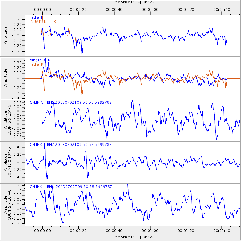
INK INUVIK, NT - Earthquake Result Viewer
*The percent match for this event was below the threshold and hence no stack was calculated.
| Earthquake location: |
Tonga Islands |
| Earthquake latitude/longitude: |
-15.7/-173.8 |
| Earthquake time(UTC): |
2013/07/02 (183) 09:38:41 GMT |
| Earthquake Depth: |
47 km |
| Earthquake Magnitude: |
5.5 MW, 5.6 MB |
| Earthquake Catalog/Contributor: |
NEIC PDE/NEIC PDE-W |
|
| Network: |
CN Canadian National Seismograph Network |
| Station: |
INK INUVIK, NT |
| Lat/Lon: |
68.31 N/133.53 W |
| Elevation: |
44 m |
|
| Distance: |
88.7 deg |
| Az: |
13.912 deg |
| Baz: |
218.519 deg |
| Ray Param: |
$rayparam |
*The percent match for this event was below the threshold and hence was not used in the summary stack. |
|
| Radial Match: |
79.91899 % |
| Radial Bump: |
400 |
| Transverse Match: |
79.69639 % |
| Transverse Bump: |
400 |
| SOD ConfigId: |
512894 |
| Insert Time: |
2013-09-15 11:13:24.436 +0000 |
| GWidth: |
2.5 |
| Max Bumps: |
400 |
| Tol: |
0.001 |
|
Signal To Noise
| Channel | StoN | STA | LTA |
| CN:INK: :BHZ:20130702T09:50:58.599978Z | 2.530815 | 2.244876E-7 | 8.8701704E-8 |
| CN:INK: :BHN:20130702T09:50:58.599978Z | 1.7838517 | 1.0953046E-7 | 6.14011E-8 |
| CN:INK: :BHE:20130702T09:50:58.599978Z | 0.60725945 | 3.3826907E-8 | 5.570421E-8 |
| Arrivals |
| Ps | |
| PpPs | |
| PsPs/PpSs | |


