You are here: Home > Network List > TA - USArray Transportable Network (new EarthScope stations) Stations List
> Station G59A Clarenceville, QC, USA > Earthquake Result Viewer
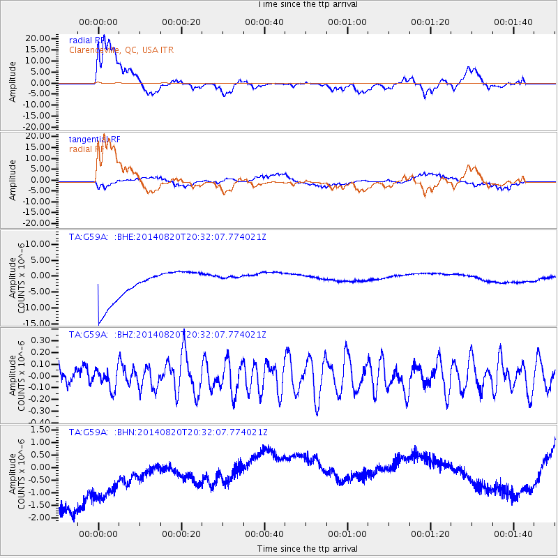
G59A Clarenceville, QC, USA - Earthquake Result Viewer
*The percent match for this event was below the threshold and hence no stack was calculated.
| Earthquake location: |
Rat Islands, Aleutian Islands |
| Earthquake latitude/longitude: |
52.5/175.4 |
| Earthquake time(UTC): |
2014/08/20 (232) 20:21:49 GMT |
| Earthquake Depth: |
10 km |
| Earthquake Magnitude: |
5.1 MW, 5.0 mb, 4.6 ML |
| Earthquake Catalog/Contributor: |
ISC/ISC |
|
| Network: |
TA USArray Transportable Network (new EarthScope stations) |
| Station: |
G59A Clarenceville, QC, USA |
| Lat/Lon: |
45.08 N/73.18 W |
| Elevation: |
36 m |
|
| Distance: |
66.4 deg |
| Az: |
46.0 deg |
| Baz: |
321.598 deg |
| Ray Param: |
$rayparam |
*The percent match for this event was below the threshold and hence was not used in the summary stack. |
|
| Radial Match: |
49.169903 % |
| Radial Bump: |
400 |
| Transverse Match: |
59.24441 % |
| Transverse Bump: |
400 |
| SOD ConfigId: |
3390531 |
| Insert Time: |
2019-04-13 12:31:44.468 +0000 |
| GWidth: |
2.5 |
| Max Bumps: |
400 |
| Tol: |
0.001 |
|
Signal To Noise
| Channel | StoN | STA | LTA |
| TA:G59A: :BHZ:20140820T20:32:07.774021Z | 0.779178 | 8.706891E-8 | 1.1174457E-7 |
| TA:G59A: :BHN:20140820T20:32:07.774021Z | 0.83476496 | 3.9276406E-6 | 4.7050858E-6 |
| TA:G59A: :BHE:20140820T20:32:07.774021Z | 0.51399064 | 2.4122908E-6 | 4.6932582E-6 |
| Arrivals |
| Ps | |
| PpPs | |
| PsPs/PpSs | |


