You are here: Home > Network List > TA - USArray Transportable Network (new EarthScope stations) Stations List
> Station R55A Marlinton, WV, USA > Earthquake Result Viewer
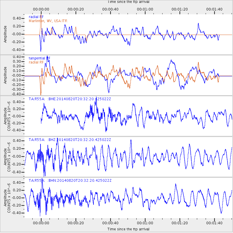
R55A Marlinton, WV, USA - Earthquake Result Viewer
*The percent match for this event was below the threshold and hence no stack was calculated.
| Earthquake location: |
Rat Islands, Aleutian Islands |
| Earthquake latitude/longitude: |
52.5/175.4 |
| Earthquake time(UTC): |
2014/08/20 (232) 20:21:49 GMT |
| Earthquake Depth: |
10 km |
| Earthquake Magnitude: |
5.1 MW, 5.0 mb, 4.6 ML |
| Earthquake Catalog/Contributor: |
ISC/ISC |
|
| Network: |
TA USArray Transportable Network (new EarthScope stations) |
| Station: |
R55A Marlinton, WV, USA |
| Lat/Lon: |
38.28 N/80.12 W |
| Elevation: |
833 m |
|
| Distance: |
68.4 deg |
| Az: |
54.997 deg |
| Baz: |
320.448 deg |
| Ray Param: |
$rayparam |
*The percent match for this event was below the threshold and hence was not used in the summary stack. |
|
| Radial Match: |
58.969837 % |
| Radial Bump: |
400 |
| Transverse Match: |
50.81516 % |
| Transverse Bump: |
400 |
| SOD ConfigId: |
3390531 |
| Insert Time: |
2019-04-13 12:32:18.045 +0000 |
| GWidth: |
2.5 |
| Max Bumps: |
400 |
| Tol: |
0.001 |
|
Signal To Noise
| Channel | StoN | STA | LTA |
| TA:R55A: :BHZ:20140820T20:32:20.425022Z | 1.4233668 | 2.0344068E-7 | 1.429292E-7 |
| TA:R55A: :BHN:20140820T20:32:20.425022Z | 1.7232088 | 2.2280693E-7 | 1.292977E-7 |
| TA:R55A: :BHE:20140820T20:32:20.425022Z | 1.6436232 | 2.3459616E-7 | 1.427311E-7 |
| Arrivals |
| Ps | |
| PpPs | |
| PsPs/PpSs | |


