You are here: Home > Network List > TA - USArray Transportable Network (new EarthScope stations) Stations List
> Station 147A Livingston, AL, USA > Earthquake Result Viewer
147A Livingston, AL, USA - Earthquake Result Viewer
| Earthquake location: |
Tonga Islands |
| Earthquake latitude/longitude: |
-15.7/-173.8 |
| Earthquake time(UTC): |
2013/07/02 (183) 09:38:41 GMT |
| Earthquake Depth: |
47 km |
| Earthquake Magnitude: |
5.5 MW, 5.6 MB |
| Earthquake Catalog/Contributor: |
NEIC PDE/NEIC PDE-W |
|
| Network: |
TA USArray Transportable Network (new EarthScope stations) |
| Station: |
147A Livingston, AL, USA |
| Lat/Lon: |
32.67 N/88.27 W |
| Elevation: |
57 m |
|
| Distance: |
94.7 deg |
| Az: |
57.527 deg |
| Baz: |
254.432 deg |
| Ray Param: |
0.04095928 |
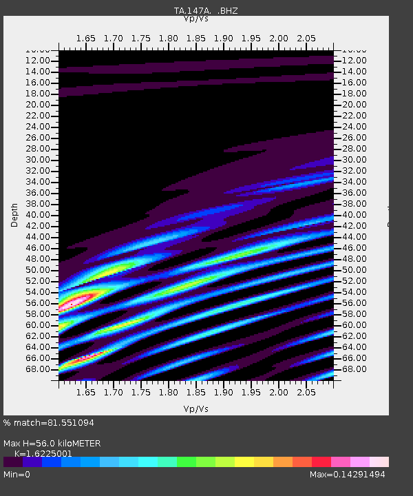
| Estimated Moho Depth: |
56.0 km |
| Estimated Crust Vp/Vs: |
1.62 |
| Assumed Crust Vp: |
6.201 km/s |
| Estimated Crust Vs: |
3.822 km/s |
| Estimated Crust Poisson's Ratio: |
0.19 |
|
| Radial Match: |
81.551094 % |
| Radial Bump: |
400 |
| Transverse Match: |
76.63733 % |
| Transverse Bump: |
400 |
| SOD ConfigId: |
512894 |
| Insert Time: |
2013-09-15 11:23:05.516 +0000 |
| GWidth: |
2.5 |
| Max Bumps: |
400 |
| Tol: |
0.001 |
|

Signal To Noise
| Channel | StoN | STA | LTA |
| TA:147A: :BHZ:20130702T09:51:26.250002Z | 0.71649677 | 5.1536196E-4 | 7.192802E-4 |
| TA:147A: :BHN:20130702T09:51:26.250002Z | 1.0252457 | 1.8858796E-4 | 1.8394415E-4 |
| TA:147A: :BHE:20130702T09:51:26.250002Z | 0.97472477 | 1.5391214E-4 | 1.5790318E-4 |
| Arrivals |
| Ps | 5.7 SECOND |
| PpPs | 23 SECOND |
| PsPs/PpSs | 29 SECOND |


