You are here: Home > Network List > TA - USArray Transportable Network (new EarthScope stations) Stations List
> Station R58B Mineral, VA, USA > Earthquake Result Viewer
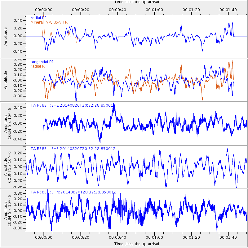
R58B Mineral, VA, USA - Earthquake Result Viewer
*The percent match for this event was below the threshold and hence no stack was calculated.
| Earthquake location: |
Rat Islands, Aleutian Islands |
| Earthquake latitude/longitude: |
52.5/175.4 |
| Earthquake time(UTC): |
2014/08/20 (232) 20:21:49 GMT |
| Earthquake Depth: |
10 km |
| Earthquake Magnitude: |
5.1 MW, 5.0 mb, 4.6 ML |
| Earthquake Catalog/Contributor: |
ISC/ISC |
|
| Network: |
TA USArray Transportable Network (new EarthScope stations) |
| Station: |
R58B Mineral, VA, USA |
| Lat/Lon: |
37.96 N/77.88 W |
| Elevation: |
116 m |
|
| Distance: |
69.8 deg |
| Az: |
53.744 deg |
| Baz: |
321.379 deg |
| Ray Param: |
$rayparam |
*The percent match for this event was below the threshold and hence was not used in the summary stack. |
|
| Radial Match: |
53.880997 % |
| Radial Bump: |
400 |
| Transverse Match: |
52.26864 % |
| Transverse Bump: |
400 |
| SOD ConfigId: |
3390531 |
| Insert Time: |
2019-04-13 12:32:18.849 +0000 |
| GWidth: |
2.5 |
| Max Bumps: |
400 |
| Tol: |
0.001 |
|
Signal To Noise
| Channel | StoN | STA | LTA |
| TA:R58B: :BHZ:20140820T20:32:28.85001Z | 0.9968073 | 7.616944E-8 | 7.641341E-8 |
| TA:R58B: :BHN:20140820T20:32:28.85001Z | 1.876066 | 1.4938045E-7 | 7.962431E-8 |
| TA:R58B: :BHE:20140820T20:32:28.85001Z | 2.2759566 | 2.1714465E-7 | 9.540808E-8 |
| Arrivals |
| Ps | |
| PpPs | |
| PsPs/PpSs | |


