You are here: Home > Network List > TA - USArray Transportable Network (new EarthScope stations) Stations List
> Station H04D Lebanon, OR, USA > Earthquake Result Viewer
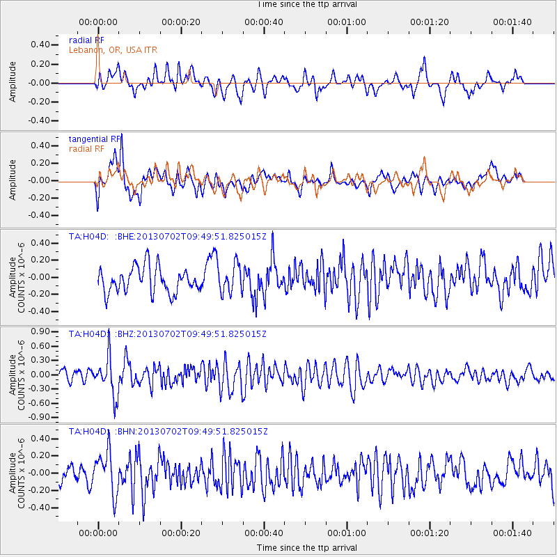
H04D Lebanon, OR, USA - Earthquake Result Viewer
*The percent match for this event was below the threshold and hence no stack was calculated.
| Earthquake location: |
Tonga Islands |
| Earthquake latitude/longitude: |
-15.7/-173.8 |
| Earthquake time(UTC): |
2013/07/02 (183) 09:38:41 GMT |
| Earthquake Depth: |
47 km |
| Earthquake Magnitude: |
5.5 MW, 5.6 MB |
| Earthquake Catalog/Contributor: |
NEIC PDE/NEIC PDE-W |
|
| Network: |
TA USArray Transportable Network (new EarthScope stations) |
| Station: |
H04D Lebanon, OR, USA |
| Lat/Lon: |
44.52 N/122.74 W |
| Elevation: |
284 m |
|
| Distance: |
75.8 deg |
| Az: |
35.02 deg |
| Baz: |
230.588 deg |
| Ray Param: |
$rayparam |
*The percent match for this event was below the threshold and hence was not used in the summary stack. |
|
| Radial Match: |
61.488792 % |
| Radial Bump: |
400 |
| Transverse Match: |
61.50303 % |
| Transverse Bump: |
400 |
| SOD ConfigId: |
512894 |
| Insert Time: |
2013-09-15 11:25:12.256 +0000 |
| GWidth: |
2.5 |
| Max Bumps: |
400 |
| Tol: |
0.001 |
|
Signal To Noise
| Channel | StoN | STA | LTA |
| TA:H04D: :BHZ:20130702T09:49:51.825015Z | 3.267338 | 4.1885386E-7 | 1.2819423E-7 |
| TA:H04D: :BHN:20130702T09:49:51.825015Z | 1.705292 | 2.550705E-7 | 1.4957585E-7 |
| TA:H04D: :BHE:20130702T09:49:51.825015Z | 1.0962136 | 1.6239004E-7 | 1.4813723E-7 |
| Arrivals |
| Ps | |
| PpPs | |
| PsPs/PpSs | |


