You are here: Home > Network List > TA - USArray Transportable Network (new EarthScope stations) Stations List
> Station TPFO Pinon Flats, CA, USA > Earthquake Result Viewer
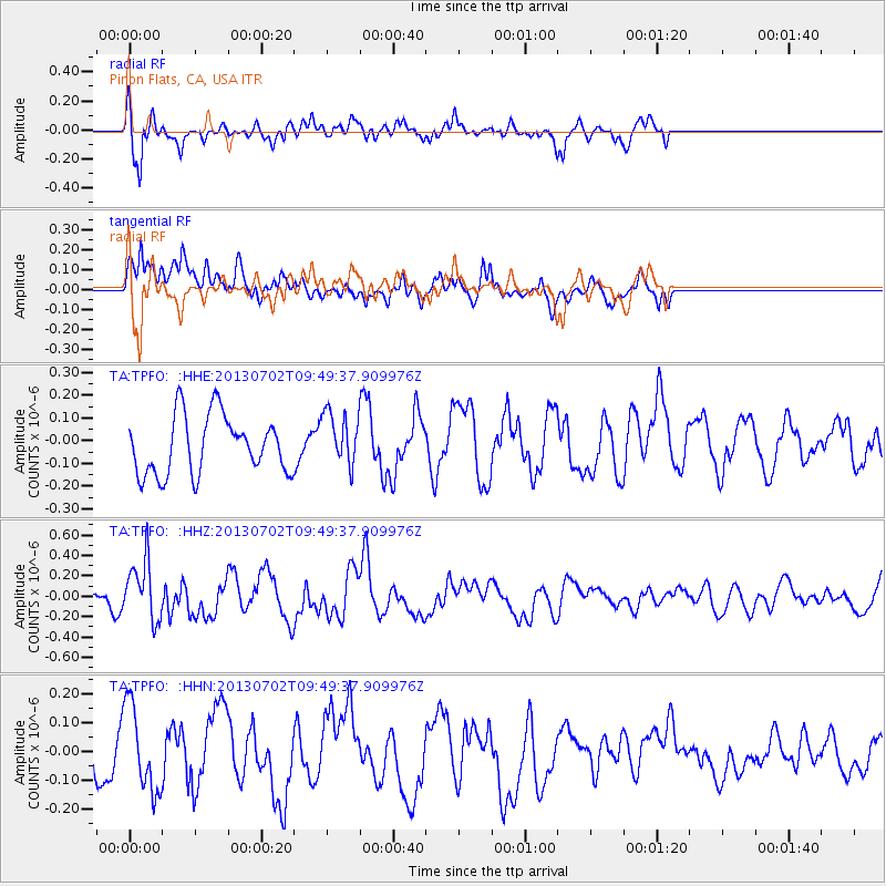
TPFO Pinon Flats, CA, USA - Earthquake Result Viewer
*The percent match for this event was below the threshold and hence no stack was calculated.
| Earthquake location: |
Tonga Islands |
| Earthquake latitude/longitude: |
-15.7/-173.8 |
| Earthquake time(UTC): |
2013/07/02 (183) 09:38:41 GMT |
| Earthquake Depth: |
47 km |
| Earthquake Magnitude: |
5.5 MW, 5.6 MB |
| Earthquake Catalog/Contributor: |
NEIC PDE/NEIC PDE-W |
|
| Network: |
TA USArray Transportable Network (new EarthScope stations) |
| Station: |
TPFO Pinon Flats, CA, USA |
| Lat/Lon: |
33.61 N/116.45 W |
| Elevation: |
1275 m |
|
| Distance: |
73.4 deg |
| Az: |
47.151 deg |
| Baz: |
237.779 deg |
| Ray Param: |
$rayparam |
*The percent match for this event was below the threshold and hence was not used in the summary stack. |
|
| Radial Match: |
67.58929 % |
| Radial Bump: |
400 |
| Transverse Match: |
72.37815 % |
| Transverse Bump: |
400 |
| SOD ConfigId: |
512894 |
| Insert Time: |
2013-09-15 11:28:20.766 +0000 |
| GWidth: |
2.5 |
| Max Bumps: |
400 |
| Tol: |
0.001 |
|
Signal To Noise
| Channel | StoN | STA | LTA |
| TA:TPFO: :HHZ:20130702T09:49:37.909976Z | 1.8366724 | 2.8766812E-7 | 1.5662462E-7 |
| TA:TPFO: :HHN:20130702T09:49:37.909976Z | 1.3909141 | 1.497516E-7 | 1.07664164E-7 |
| TA:TPFO: :HHE:20130702T09:49:37.909976Z | 0.9084462 | 1.1651155E-7 | 1.2825366E-7 |
| Arrivals |
| Ps | |
| PpPs | |
| PsPs/PpSs | |


