You are here: Home > Network List > US - United States National Seismic Network Stations List
> Station AMTX Amarillo, Texas, USA > Earthquake Result Viewer
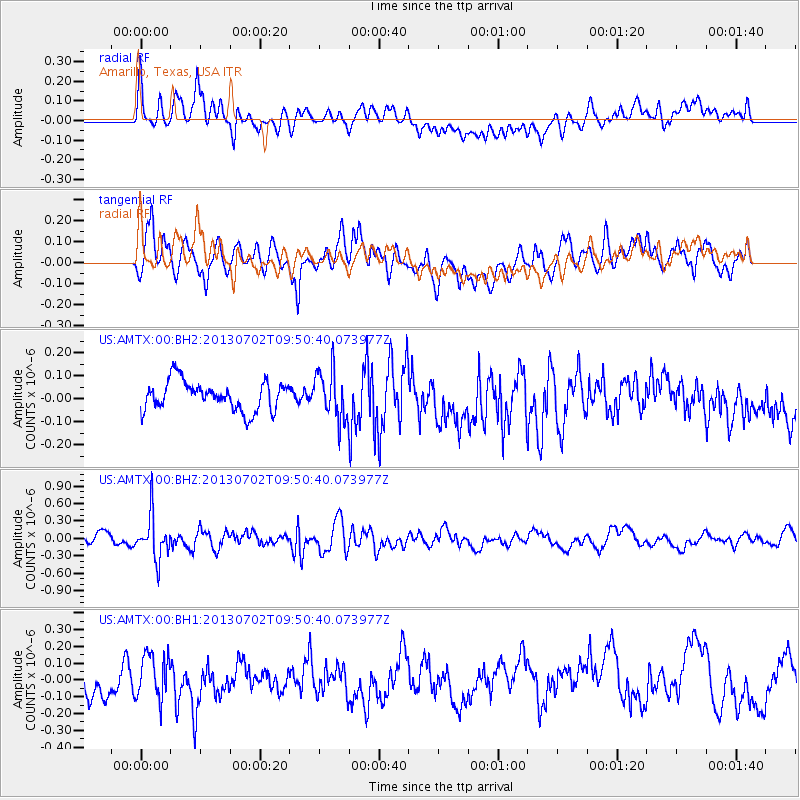
AMTX Amarillo, Texas, USA - Earthquake Result Viewer
*The percent match for this event was below the threshold and hence no stack was calculated.
| Earthquake location: |
Tonga Islands |
| Earthquake latitude/longitude: |
-15.7/-173.8 |
| Earthquake time(UTC): |
2013/07/02 (183) 09:38:41 GMT |
| Earthquake Depth: |
47 km |
| Earthquake Magnitude: |
5.5 MW, 5.6 MB |
| Earthquake Catalog/Contributor: |
NEIC PDE/NEIC PDE-W |
|
| Network: |
US United States National Seismic Network |
| Station: |
AMTX Amarillo, Texas, USA |
| Lat/Lon: |
34.53 N/101.41 W |
| Elevation: |
1010 m |
|
| Distance: |
84.9 deg |
| Az: |
52.189 deg |
| Baz: |
247.153 deg |
| Ray Param: |
$rayparam |
*The percent match for this event was below the threshold and hence was not used in the summary stack. |
|
| Radial Match: |
45.048683 % |
| Radial Bump: |
400 |
| Transverse Match: |
58.241314 % |
| Transverse Bump: |
400 |
| SOD ConfigId: |
512894 |
| Insert Time: |
2013-09-15 11:30:17.210 +0000 |
| GWidth: |
2.5 |
| Max Bumps: |
400 |
| Tol: |
0.001 |
|
Signal To Noise
| Channel | StoN | STA | LTA |
| US:AMTX:00:BHZ:20130702T09:50:40.073977Z | 2.8310022 | 3.7123732E-7 | 1.3113284E-7 |
| US:AMTX:00:BH1:20130702T09:50:40.073977Z | 1.6790456 | 1.3520086E-7 | 8.052245E-8 |
| US:AMTX:00:BH2:20130702T09:50:40.073977Z | 1.9250681 | 1.200021E-7 | 6.233654E-8 |
| Arrivals |
| Ps | |
| PpPs | |
| PsPs/PpSs | |


