You are here: Home > Network List > US - United States National Seismic Network Stations List
> Station AMTX Amarillo, Texas, USA > Earthquake Result Viewer
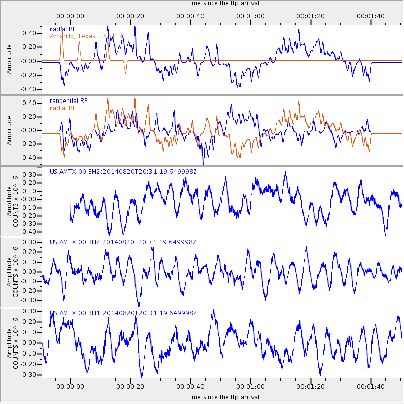
AMTX Amarillo, Texas, USA - Earthquake Result Viewer
*The percent match for this event was below the threshold and hence no stack was calculated.
| Earthquake location: |
Rat Islands, Aleutian Islands |
| Earthquake latitude/longitude: |
52.5/175.4 |
| Earthquake time(UTC): |
2014/08/20 (232) 20:21:49 GMT |
| Earthquake Depth: |
10 km |
| Earthquake Magnitude: |
5.1 MW, 5.0 mb, 4.6 ML |
| Earthquake Catalog/Contributor: |
ISC/ISC |
|
| Network: |
US United States National Seismic Network |
| Station: |
AMTX Amarillo, Texas, USA |
| Lat/Lon: |
34.53 N/101.41 W |
| Elevation: |
1010 m |
|
| Distance: |
59.6 deg |
| Az: |
71.885 deg |
| Baz: |
315.227 deg |
| Ray Param: |
$rayparam |
*The percent match for this event was below the threshold and hence was not used in the summary stack. |
|
| Radial Match: |
54.23717 % |
| Radial Bump: |
400 |
| Transverse Match: |
44.893826 % |
| Transverse Bump: |
400 |
| SOD ConfigId: |
3390531 |
| Insert Time: |
2019-04-13 12:33:05.510 +0000 |
| GWidth: |
2.5 |
| Max Bumps: |
400 |
| Tol: |
0.001 |
|
Signal To Noise
| Channel | StoN | STA | LTA |
| US:AMTX:00:BHZ:20140820T20:31:19.649998Z | 0.91878974 | 8.814906E-8 | 9.59404E-8 |
| US:AMTX:00:BH1:20140820T20:31:19.649998Z | 1.120743 | 1.3900816E-7 | 1.2403216E-7 |
| US:AMTX:00:BH2:20140820T20:31:19.649998Z | 1.289913 | 1.8838863E-7 | 1.4604754E-7 |
| Arrivals |
| Ps | |
| PpPs | |
| PsPs/PpSs | |


