You are here: Home > Network List > US - United States National Seismic Network Stations List
> Station WUAZ Wupatki, Arizona, USA > Earthquake Result Viewer
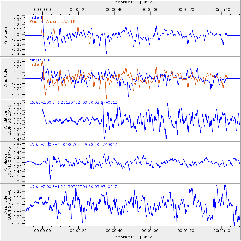
WUAZ Wupatki, Arizona, USA - Earthquake Result Viewer
*The percent match for this event was below the threshold and hence no stack was calculated.
| Earthquake location: |
Tonga Islands |
| Earthquake latitude/longitude: |
-15.7/-173.8 |
| Earthquake time(UTC): |
2013/07/02 (183) 09:38:41 GMT |
| Earthquake Depth: |
47 km |
| Earthquake Magnitude: |
5.5 MW, 5.6 MB |
| Earthquake Catalog/Contributor: |
NEIC PDE/NEIC PDE-W |
|
| Network: |
US United States National Seismic Network |
| Station: |
WUAZ Wupatki, Arizona, USA |
| Lat/Lon: |
35.52 N/111.37 W |
| Elevation: |
1592 m |
|
| Distance: |
78.0 deg |
| Az: |
47.671 deg |
| Baz: |
240.778 deg |
| Ray Param: |
$rayparam |
*The percent match for this event was below the threshold and hence was not used in the summary stack. |
|
| Radial Match: |
68.94342 % |
| Radial Bump: |
400 |
| Transverse Match: |
76.101585 % |
| Transverse Bump: |
400 |
| SOD ConfigId: |
512894 |
| Insert Time: |
2013-09-15 11:31:45.729 +0000 |
| GWidth: |
2.5 |
| Max Bumps: |
400 |
| Tol: |
0.001 |
|
Signal To Noise
| Channel | StoN | STA | LTA |
| US:WUAZ:00:BHZ:20130702T09:50:03.974001Z | 9.486975 | 3.3234915E-7 | 3.503215E-8 |
| US:WUAZ:00:BH1:20130702T09:50:03.974001Z | 1.0745168 | 6.931441E-8 | 6.450752E-8 |
| US:WUAZ:00:BH2:20130702T09:50:03.974001Z | 3.1428416 | 1.5569562E-7 | 4.9539757E-8 |
| Arrivals |
| Ps | |
| PpPs | |
| PsPs/PpSs | |


