You are here: Home > Network List > US - United States National Seismic Network Stations List
> Station WVOR Wild Horse Valley, Oregon, USA > Earthquake Result Viewer
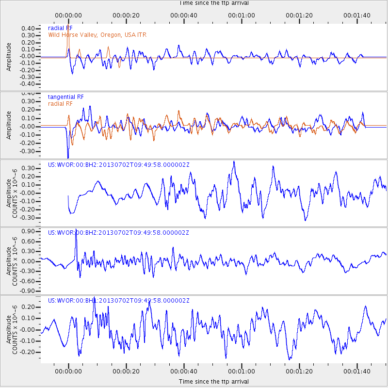
WVOR Wild Horse Valley, Oregon, USA - Earthquake Result Viewer
*The percent match for this event was below the threshold and hence no stack was calculated.
| Earthquake location: |
Tonga Islands |
| Earthquake latitude/longitude: |
-15.7/-173.8 |
| Earthquake time(UTC): |
2013/07/02 (183) 09:38:41 GMT |
| Earthquake Depth: |
47 km |
| Earthquake Magnitude: |
5.5 MW, 5.6 MB |
| Earthquake Catalog/Contributor: |
NEIC PDE/NEIC PDE-W |
|
| Network: |
US United States National Seismic Network |
| Station: |
WVOR Wild Horse Valley, Oregon, USA |
| Lat/Lon: |
42.43 N/118.64 W |
| Elevation: |
1344 m |
|
| Distance: |
76.9 deg |
| Az: |
38.596 deg |
| Baz: |
234.243 deg |
| Ray Param: |
$rayparam |
*The percent match for this event was below the threshold and hence was not used in the summary stack. |
|
| Radial Match: |
40.11204 % |
| Radial Bump: |
400 |
| Transverse Match: |
54.76355 % |
| Transverse Bump: |
400 |
| SOD ConfigId: |
512894 |
| Insert Time: |
2013-09-15 11:31:46.969 +0000 |
| GWidth: |
2.5 |
| Max Bumps: |
400 |
| Tol: |
0.001 |
|
Signal To Noise
| Channel | StoN | STA | LTA |
| US:WVOR:00:BHZ:20130702T09:49:58.000002Z | 2.3011034 | 2.9798116E-7 | 1.2949491E-7 |
| US:WVOR:00:BH1:20130702T09:49:58.000002Z | 1.8855815 | 1.1889312E-7 | 6.305382E-8 |
| US:WVOR:00:BH2:20130702T09:49:58.000002Z | 1.0668002 | 9.578515E-8 | 8.978733E-8 |
| Arrivals |
| Ps | |
| PpPs | |
| PsPs/PpSs | |


