You are here: Home > Network List > UU - University of Utah Regional Network Stations List
> Station KNB Kanab, UT, USA > Earthquake Result Viewer
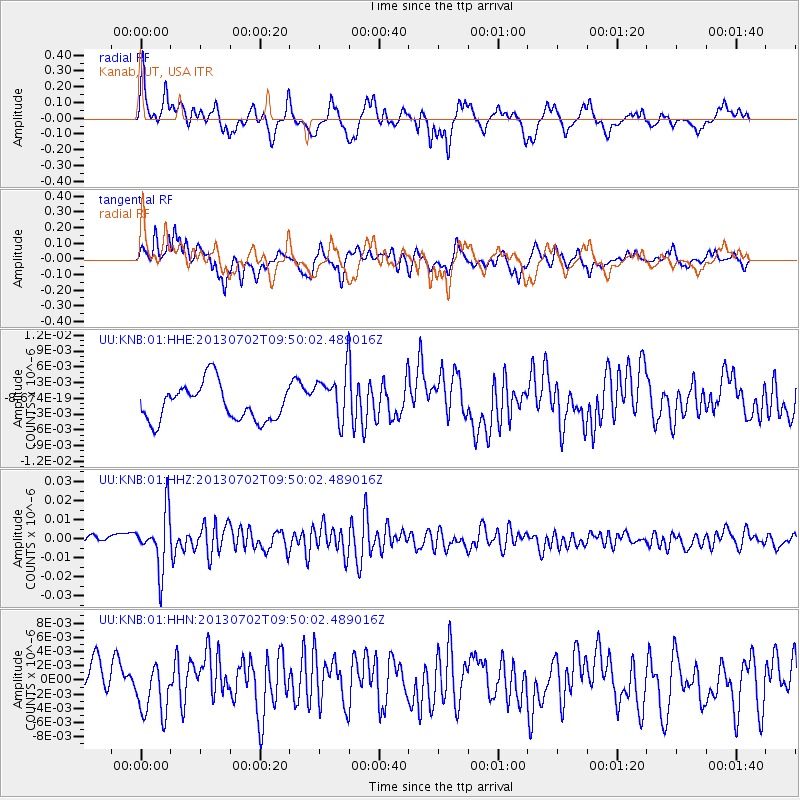
KNB Kanab, UT, USA - Earthquake Result Viewer
*The percent match for this event was below the threshold and hence no stack was calculated.
| Earthquake location: |
Tonga Islands |
| Earthquake latitude/longitude: |
-15.7/-173.8 |
| Earthquake time(UTC): |
2013/07/02 (183) 09:38:41 GMT |
| Earthquake Depth: |
47 km |
| Earthquake Magnitude: |
5.5 MW, 5.6 MB |
| Earthquake Catalog/Contributor: |
NEIC PDE/NEIC PDE-W |
|
| Network: |
UU University of Utah Regional Network |
| Station: |
KNB Kanab, UT, USA |
| Lat/Lon: |
37.02 N/112.82 W |
| Elevation: |
1715 m |
|
| Distance: |
77.7 deg |
| Az: |
45.747 deg |
| Baz: |
239.521 deg |
| Ray Param: |
$rayparam |
*The percent match for this event was below the threshold and hence was not used in the summary stack. |
|
| Radial Match: |
73.168526 % |
| Radial Bump: |
400 |
| Transverse Match: |
70.81979 % |
| Transverse Bump: |
400 |
| SOD ConfigId: |
512894 |
| Insert Time: |
2013-09-15 11:32:17.688 +0000 |
| GWidth: |
2.5 |
| Max Bumps: |
400 |
| Tol: |
0.001 |
|
Signal To Noise
| Channel | StoN | STA | LTA |
| UU:KNB:01:HHZ:20130702T09:50:02.489016Z | 5.107553 | 1.4527868E-8 | 2.844389E-9 |
| UU:KNB:01:HHN:20130702T09:50:02.489016Z | 1.7084486 | 3.778159E-9 | 2.211456E-9 |
| UU:KNB:01:HHE:20130702T09:50:02.489016Z | 1.3984317 | 4.8178914E-9 | 3.4452106E-9 |
| Arrivals |
| Ps | |
| PpPs | |
| PsPs/PpSs | |


