LTY Liberty (broad-band) - Earthquake Result Viewer
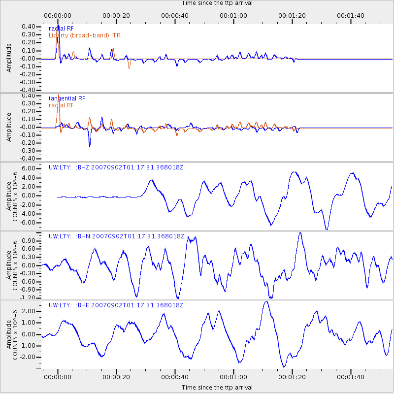
Earthquake location: Santa Cruz Islands
Earthquake latitude/longitude: -11.6/165.8
Earthquake time(UTC): 2007/09/02 (245) 01:05:18 GMT
Earthquake Depth: 35 km
Earthquake Magnitude: 5.9 MB, 7.3 MS, 7.2 MW, 6.9 ME
Earthquake Catalog/Contributor: WHDF/NEIC
Network: UW Pacific Northwest Regional Seismic Network
Station: LTY Liberty (broad-band)
Lat/Lon: 47.26 N/120.66 W
Elevation: 970 m
Distance: 87.6 deg
Az: 40.841 deg
Baz: 250.162 deg
Ray Param: 0.043182816
Estimated Moho Depth: 29.0 km
Estimated Crust Vp/Vs: 1.60
Assumed Crust Vp: 6.597 km/s
Estimated Crust Vs: 4.123 km/s
Estimated Crust Poisson's Ratio: 0.18
Radial Match: 96.83978 %
Radial Bump: 400
Transverse Match: 94.45838 %
Transverse Bump: 398
SOD ConfigId: 2564
Insert Time: 2010-02-27 04:48:02.193 +0000
GWidth: 2.5
Max Bumps: 400
Tol: 0.001

Signal To Noise

ChannelStoNSTALTA
UW:LTY: :BHN:20070902T01:17:31.368018Z1.26552131.2462262E-79.847532E-8
UW:LTY: :BHE:20070902T01:17:31.368018Z9.6095658.9633346E-79.327514E-8
UW:LTY: :BHZ:20070902T01:17:31.368018Z40.2386742.4683889E-66.13437E-8
Arrivals
Ps2.7 SECOND
PpPs11 SECOND
PsPs/PpSs14 SECOND