You are here: Home > Network List > UW - Pacific Northwest Regional Seismic Network Stations List
> Station LEBA Lebam, WA, USA > Earthquake Result Viewer
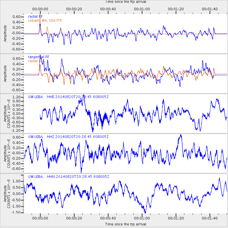
LEBA Lebam, WA, USA - Earthquake Result Viewer
*The percent match for this event was below the threshold and hence no stack was calculated.
| Earthquake location: |
Rat Islands, Aleutian Islands |
| Earthquake latitude/longitude: |
52.5/175.4 |
| Earthquake time(UTC): |
2014/08/20 (232) 20:21:49 GMT |
| Earthquake Depth: |
10 km |
| Earthquake Magnitude: |
5.1 MW, 5.0 mb, 4.6 ML |
| Earthquake Catalog/Contributor: |
ISC/ISC |
|
| Network: |
UW Pacific Northwest Regional Seismic Network |
| Station: |
LEBA Lebam, WA, USA |
| Lat/Lon: |
46.55 N/123.56 W |
| Elevation: |
73 m |
|
| Distance: |
39.0 deg |
| Az: |
73.527 deg |
| Baz: |
301.787 deg |
| Ray Param: |
$rayparam |
*The percent match for this event was below the threshold and hence was not used in the summary stack. |
|
| Radial Match: |
48.366856 % |
| Radial Bump: |
400 |
| Transverse Match: |
49.617966 % |
| Transverse Bump: |
345 |
| SOD ConfigId: |
3390531 |
| Insert Time: |
2019-04-13 12:33:28.316 +0000 |
| GWidth: |
2.5 |
| Max Bumps: |
400 |
| Tol: |
0.001 |
|
Signal To Noise
| Channel | StoN | STA | LTA |
| UW:LEBA: :HHZ:20140820T20:28:45.608005Z | 1.2371541 | 2.8808796E-7 | 2.3286344E-7 |
| UW:LEBA: :HHN:20140820T20:28:45.608005Z | 1.2247962 | 4.739458E-7 | 3.869589E-7 |
| UW:LEBA: :HHE:20140820T20:28:45.608005Z | 1.5929059 | 6.4754295E-7 | 4.0651676E-7 |
| Arrivals |
| Ps | |
| PpPs | |
| PsPs/PpSs | |


