You are here: Home > Network List > UW - Pacific Northwest Regional Seismic Network Stations List
> Station MRBL Marblemount, WA, USA > Earthquake Result Viewer
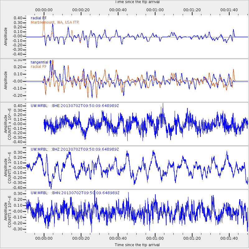
MRBL Marblemount, WA, USA - Earthquake Result Viewer
*The percent match for this event was below the threshold and hence no stack was calculated.
| Earthquake location: |
Tonga Islands |
| Earthquake latitude/longitude: |
-15.7/-173.8 |
| Earthquake time(UTC): |
2013/07/02 (183) 09:38:41 GMT |
| Earthquake Depth: |
47 km |
| Earthquake Magnitude: |
5.5 MW, 5.6 MB |
| Earthquake Catalog/Contributor: |
NEIC PDE/NEIC PDE-W |
|
| Network: |
UW Pacific Northwest Regional Seismic Network |
| Station: |
MRBL Marblemount, WA, USA |
| Lat/Lon: |
48.52 N/121.48 W |
| Elevation: |
75 m |
|
| Distance: |
79.0 deg |
| Az: |
32.411 deg |
| Baz: |
230.927 deg |
| Ray Param: |
$rayparam |
*The percent match for this event was below the threshold and hence was not used in the summary stack. |
|
| Radial Match: |
65.67988 % |
| Radial Bump: |
400 |
| Transverse Match: |
70.11915 % |
| Transverse Bump: |
400 |
| SOD ConfigId: |
512894 |
| Insert Time: |
2013-09-15 11:33:52.320 +0000 |
| GWidth: |
2.5 |
| Max Bumps: |
400 |
| Tol: |
0.001 |
|
Signal To Noise
| Channel | StoN | STA | LTA |
| UW:MRBL: :BHZ:20130702T09:50:09.648989Z | 2.3398914 | 2.0565788E-7 | 8.789206E-8 |
| UW:MRBL: :BHN:20130702T09:50:09.648989Z | 1.2946321 | 1.226987E-7 | 9.4774954E-8 |
| UW:MRBL: :BHE:20130702T09:50:09.648989Z | 1.2439245 | 1.350001E-7 | 1.0852757E-7 |
| Arrivals |
| Ps | |
| PpPs | |
| PsPs/PpSs | |


