You are here: Home > Network List > TA - USArray Transportable Network (new EarthScope stations) Stations List
> Station M53A WI Miller and Sons, Farmdale, OH, USA > Earthquake Result Viewer
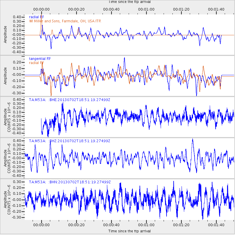
M53A WI Miller and Sons, Farmdale, OH, USA - Earthquake Result Viewer
*The percent match for this event was below the threshold and hence no stack was calculated.
| Earthquake location: |
Southeast Of Easter Island |
| Earthquake latitude/longitude: |
-35.9/-103.0 |
| Earthquake time(UTC): |
2013/07/02 (183) 18:39:43 GMT |
| Earthquake Depth: |
10 km |
| Earthquake Magnitude: |
5.7 MW, 5.5 MW |
| Earthquake Catalog/Contributor: |
NEIC PDE/NEIC PDE-W |
|
| Network: |
TA USArray Transportable Network (new EarthScope stations) |
| Station: |
M53A WI Miller and Sons, Farmdale, OH, USA |
| Lat/Lon: |
41.44 N/80.68 W |
| Elevation: |
334 m |
|
| Distance: |
79.7 deg |
| Az: |
16.85 deg |
| Baz: |
198.235 deg |
| Ray Param: |
$rayparam |
*The percent match for this event was below the threshold and hence was not used in the summary stack. |
|
| Radial Match: |
42.57035 % |
| Radial Bump: |
400 |
| Transverse Match: |
47.75306 % |
| Transverse Bump: |
400 |
| SOD ConfigId: |
512894 |
| Insert Time: |
2013-09-15 12:07:56.149 +0000 |
| GWidth: |
2.5 |
| Max Bumps: |
400 |
| Tol: |
0.001 |
|
Signal To Noise
| Channel | StoN | STA | LTA |
| TA:M53A: :BHZ:20130702T18:51:19.27499Z | 1.3141443 | 1.2924892E-7 | 9.835215E-8 |
| TA:M53A: :BHN:20130702T18:51:19.27499Z | 0.6531176 | 9.134109E-8 | 1.3985398E-7 |
| TA:M53A: :BHE:20130702T18:51:19.27499Z | 0.65717906 | 1.08679544E-7 | 1.6537281E-7 |
| Arrivals |
| Ps | |
| PpPs | |
| PsPs/PpSs | |


