LTY Liberty (broad-band) - Earthquake Result Viewer
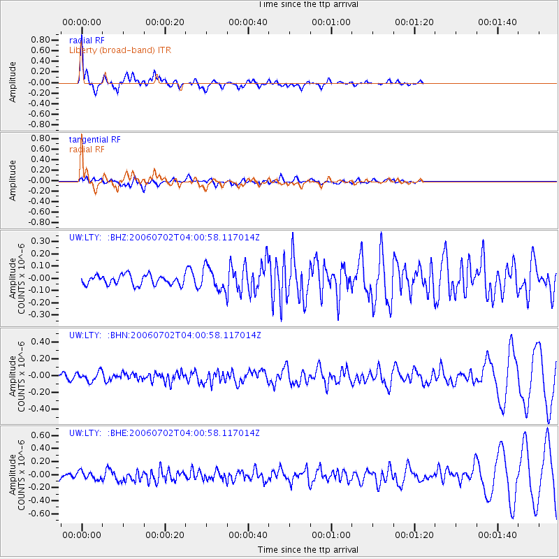
Earthquake location: Rat Islands, Aleutian Islands
Earthquake latitude/longitude: 51.7/176.9
Earthquake time(UTC): 2006/07/02 (183) 03:53:56 GMT
Earthquake Depth: 8.6 km
Earthquake Magnitude: 5.5 MB, 5.3 MS, 5.8 MW, 5.7 MW
Earthquake Catalog/Contributor: WHDF/NEIC
Network: UW Pacific Northwest Regional Seismic Network
Station: LTY Liberty (broad-band)
Lat/Lon: 47.26 N/120.66 W
Elevation: 970 m
Distance: 39.7 deg
Az: 70.949 deg
Baz: 300.307 deg
Ray Param: 0.07484093
Estimated Moho Depth: 61.5 km
Estimated Crust Vp/Vs: 2.10
Assumed Crust Vp: 6.597 km/s
Estimated Crust Vs: 3.149 km/s
Estimated Crust Poisson's Ratio: 0.35
Radial Match: 89.888695 %
Radial Bump: 372
Transverse Match: 47.034252 %
Transverse Bump: 400
SOD ConfigId: 2665
Insert Time: 2010-02-27 04:49:06.933 +0000
GWidth: 2.5
Max Bumps: 400
Tol: 0.001

Signal To Noise

ChannelStoNSTALTA
UW:LTY: :BHN:20060702T04:00:58.117014Z1.23164565.6192224E-84.5623697E-8
UW:LTY: :BHE:20060702T04:00:58.117014Z0.86791246.400028E-87.374049E-8
UW:LTY: :BHZ:20060702T04:00:58.117014Z2.37168039.373066E-83.952078E-8
Arrivals
Ps11 SECOND
PpPs27 SECOND
PsPs/PpSs38 SECOND