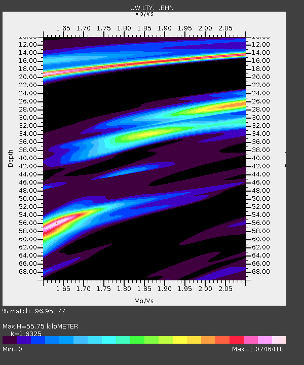
LTY Liberty (broad-band) - Earthquake Result Viewer

Earthquake location: Rat Islands, Aleutian Islands
Earthquake latitude/longitude: 51.8/177.1
Earthquake time(UTC): 2006/06/14 (165) 04:18:42 GMT
Earthquake Depth: 14 km
Earthquake Magnitude: 5.9 MB, 6.4 MS, 6.4 MW, 6.4 MW
Earthquake Catalog/Contributor: WHDF/NEIC
Network: UW Pacific Northwest Regional Seismic Network
Station: LTY Liberty (broad-band)
Lat/Lon: 47.26 N/120.66 W
Elevation: 970 m
Distance: 39.6 deg
Az: 71.076 deg
Baz: 300.317 deg
Ray Param: 0.07488585
Estimated Moho Depth: 55.75 km
Estimated Crust Vp/Vs: 1.63
Assumed Crust Vp: 6.597 km/s
Estimated Crust Vs: 4.041 km/s
Estimated Crust Poisson's Ratio: 0.20
Radial Match: 96.95177 %
Radial Bump: 220
Transverse Match: 82.43496 %
Transverse Bump: 400
SOD ConfigId: 5745
Insert Time: 2010-02-27 04:49:08.805 +0000
GWidth: 2.5
Max Bumps: 400
Tol: 0.001

Signal To Noise

ChannelStoNSTALTA
UW:LTY: :BHN:20060614T04:25:42.459005Z1.08420041.4854884E-71.3701235E-7
UW:LTY: :BHE:20060614T04:25:42.459005Z2.52221751.9456691E-77.714121E-8
UW:LTY: :BHZ:20060614T04:25:42.459005Z3.9377734.5336554E-71.15132465E-7
Arrivals
Ps5.8 SECOND
PpPs20 SECOND
PsPs/PpSs26 SECOND