You are here: Home > Network List > TA - USArray Transportable Network (new EarthScope stations) Stations List
> Station J47A Sunmer, MI, USA > Earthquake Result Viewer
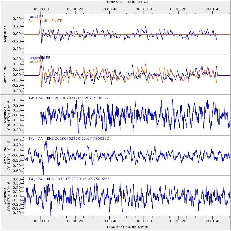
J47A Sunmer, MI, USA - Earthquake Result Viewer
*The percent match for this event was below the threshold and hence no stack was calculated.
| Earthquake location: |
Jujuy Province, Argentina |
| Earthquake latitude/longitude: |
-23.9/-66.5 |
| Earthquake time(UTC): |
2013/07/02 (183) 20:04:55 GMT |
| Earthquake Depth: |
199 km |
| Earthquake Magnitude: |
5.6 MW, 5.7 MW |
| Earthquake Catalog/Contributor: |
NEIC PDE/NEIC PDE-W |
|
| Network: |
TA USArray Transportable Network (new EarthScope stations) |
| Station: |
J47A Sunmer, MI, USA |
| Lat/Lon: |
43.24 N/84.82 W |
| Elevation: |
236 m |
|
| Distance: |
68.9 deg |
| Az: |
345.753 deg |
| Baz: |
162.041 deg |
| Ray Param: |
$rayparam |
*The percent match for this event was below the threshold and hence was not used in the summary stack. |
|
| Radial Match: |
46.962933 % |
| Radial Bump: |
400 |
| Transverse Match: |
59.760098 % |
| Transverse Bump: |
400 |
| SOD ConfigId: |
512894 |
| Insert Time: |
2013-09-15 12:46:12.294 +0000 |
| GWidth: |
2.5 |
| Max Bumps: |
400 |
| Tol: |
0.001 |
|
Signal To Noise
| Channel | StoN | STA | LTA |
| TA:J47A: :BHZ:20130702T20:15:07.750022Z | 2.9149787 | 3.416348E-7 | 1.1719976E-7 |
| TA:J47A: :BHN:20130702T20:15:07.750022Z | 1.295681 | 1.6408248E-7 | 1.2663803E-7 |
| TA:J47A: :BHE:20130702T20:15:07.750022Z | 1.052244 | 1.1547711E-7 | 1.0974367E-7 |
| Arrivals |
| Ps | |
| PpPs | |
| PsPs/PpSs | |


