You are here: Home > Network List > TA - USArray Transportable Network (new EarthScope stations) Stations List
> Station L42A Oliver, Polo, IL, USA > Earthquake Result Viewer
L42A Oliver, Polo, IL, USA - Earthquake Result Viewer
*The percent match for this event was below the threshold and hence no stack was calculated.
| Earthquake location: |
Jujuy Province, Argentina |
| Earthquake latitude/longitude: |
-23.9/-66.5 |
| Earthquake time(UTC): |
2013/07/02 (183) 20:04:55 GMT |
| Earthquake Depth: |
199 km |
| Earthquake Magnitude: |
5.6 MW, 5.7 MW |
| Earthquake Catalog/Contributor: |
NEIC PDE/NEIC PDE-W |
|
| Network: |
TA USArray Transportable Network (new EarthScope stations) |
| Station: |
L42A Oliver, Polo, IL, USA |
| Lat/Lon: |
42.00 N/89.67 W |
| Elevation: |
257 m |
|
| Distance: |
68.9 deg |
| Az: |
341.699 deg |
| Baz: |
157.31 deg |
| Ray Param: |
$rayparam |
*The percent match for this event was below the threshold and hence was not used in the summary stack. |
|
| Radial Match: |
55.34815 % |
| Radial Bump: |
400 |
| Transverse Match: |
56.593636 % |
| Transverse Bump: |
400 |
| SOD ConfigId: |
512894 |
| Insert Time: |
2013-09-15 12:47:06.443 +0000 |
| GWidth: |
2.5 |
| Max Bumps: |
400 |
| Tol: |
0.001 |
|
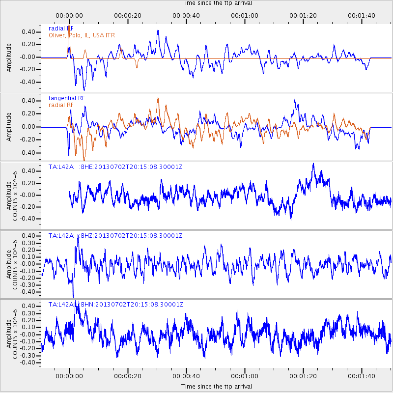
Signal To Noise
| Channel | StoN | STA | LTA |
| TA:L42A: :BHZ:20130702T20:15:08.30001Z | 2.1531591 | 2.2726198E-7 | 1.0554815E-7 |
| TA:L42A: :BHN:20130702T20:15:08.30001Z | 2.9842417 | 3.2479952E-7 | 1.0883821E-7 |
| TA:L42A: :BHE:20130702T20:15:08.30001Z | 1.0175761 | 1.1636963E-7 | 1.14359636E-7 |
| Arrivals |
| Ps | |
| PpPs | |
| PsPs/PpSs | |


