You are here: Home > Network List > TA - USArray Transportable Network (new EarthScope stations) Stations List
> Station L48A N Adams, MI, USA > Earthquake Result Viewer
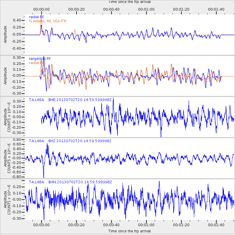
L48A N Adams, MI, USA - Earthquake Result Viewer
*The percent match for this event was below the threshold and hence no stack was calculated.
| Earthquake location: |
Jujuy Province, Argentina |
| Earthquake latitude/longitude: |
-23.9/-66.5 |
| Earthquake time(UTC): |
2013/07/02 (183) 20:04:55 GMT |
| Earthquake Depth: |
199 km |
| Earthquake Magnitude: |
5.6 MW, 5.7 MW |
| Earthquake Catalog/Contributor: |
NEIC PDE/NEIC PDE-W |
|
| Network: |
TA USArray Transportable Network (new EarthScope stations) |
| Station: |
L48A N Adams, MI, USA |
| Lat/Lon: |
41.94 N/84.43 W |
| Elevation: |
369 m |
|
| Distance: |
67.5 deg |
| Az: |
345.62 deg |
| Baz: |
162.253 deg |
| Ray Param: |
$rayparam |
*The percent match for this event was below the threshold and hence was not used in the summary stack. |
|
| Radial Match: |
57.909904 % |
| Radial Bump: |
400 |
| Transverse Match: |
58.086708 % |
| Transverse Bump: |
400 |
| SOD ConfigId: |
512894 |
| Insert Time: |
2013-09-15 12:47:14.705 +0000 |
| GWidth: |
2.5 |
| Max Bumps: |
400 |
| Tol: |
0.001 |
|
Signal To Noise
| Channel | StoN | STA | LTA |
| TA:L48A: :BHZ:20130702T20:14:59.599998Z | 3.1683297 | 2.9206925E-7 | 9.218398E-8 |
| TA:L48A: :BHN:20130702T20:14:59.599998Z | 0.9904713 | 1.12694735E-7 | 1.137789E-7 |
| TA:L48A: :BHE:20130702T20:14:59.599998Z | 1.2576302 | 1.12016146E-7 | 8.9069225E-8 |
| Arrivals |
| Ps | |
| PpPs | |
| PsPs/PpSs | |


