You are here: Home > Network List > TA - USArray Transportable Network (new EarthScope stations) Stations List
> Station M51A Elyria, OH, USA > Earthquake Result Viewer
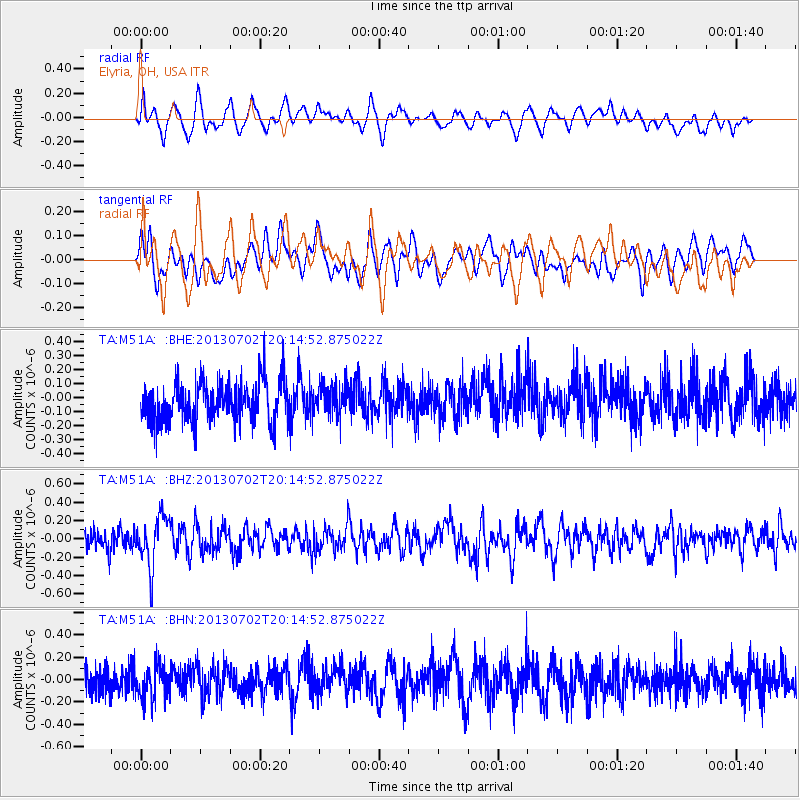
M51A Elyria, OH, USA - Earthquake Result Viewer
*The percent match for this event was below the threshold and hence no stack was calculated.
| Earthquake location: |
Jujuy Province, Argentina |
| Earthquake latitude/longitude: |
-23.9/-66.5 |
| Earthquake time(UTC): |
2013/07/02 (183) 20:04:55 GMT |
| Earthquake Depth: |
199 km |
| Earthquake Magnitude: |
5.6 MW, 5.7 MW |
| Earthquake Catalog/Contributor: |
NEIC PDE/NEIC PDE-W |
|
| Network: |
TA USArray Transportable Network (new EarthScope stations) |
| Station: |
M51A Elyria, OH, USA |
| Lat/Lon: |
41.33 N/82.18 W |
| Elevation: |
239 m |
|
| Distance: |
66.5 deg |
| Az: |
347.184 deg |
| Baz: |
164.354 deg |
| Ray Param: |
$rayparam |
*The percent match for this event was below the threshold and hence was not used in the summary stack. |
|
| Radial Match: |
61.034393 % |
| Radial Bump: |
400 |
| Transverse Match: |
41.604507 % |
| Transverse Bump: |
400 |
| SOD ConfigId: |
512894 |
| Insert Time: |
2013-09-15 12:47:59.242 +0000 |
| GWidth: |
2.5 |
| Max Bumps: |
400 |
| Tol: |
0.001 |
|
Signal To Noise
| Channel | StoN | STA | LTA |
| TA:M51A: :BHZ:20130702T20:14:52.875022Z | 2.3427162 | 2.6895356E-7 | 1.1480416E-7 |
| TA:M51A: :BHN:20130702T20:14:52.875022Z | 1.108786 | 1.522326E-7 | 1.3729665E-7 |
| TA:M51A: :BHE:20130702T20:14:52.875022Z | 0.7520071 | 1.08400336E-7 | 1.4414802E-7 |
| Arrivals |
| Ps | |
| PpPs | |
| PsPs/PpSs | |


