You are here: Home > Network List > TA - USArray Transportable Network (new EarthScope stations) Stations List
> Station MDND Maddock, ND, USA > Earthquake Result Viewer
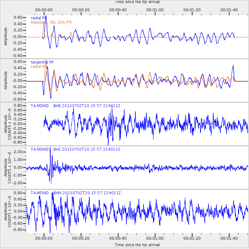
MDND Maddock, ND, USA - Earthquake Result Viewer
*The percent match for this event was below the threshold and hence no stack was calculated.
| Earthquake location: |
Jujuy Province, Argentina |
| Earthquake latitude/longitude: |
-23.9/-66.5 |
| Earthquake time(UTC): |
2013/07/02 (183) 20:04:55 GMT |
| Earthquake Depth: |
199 km |
| Earthquake Magnitude: |
5.6 MW, 5.7 MW |
| Earthquake Catalog/Contributor: |
NEIC PDE/NEIC PDE-W |
|
| Network: |
TA USArray Transportable Network (new EarthScope stations) |
| Station: |
MDND Maddock, ND, USA |
| Lat/Lon: |
47.85 N/99.60 W |
| Elevation: |
479 m |
|
| Distance: |
77.3 deg |
| Az: |
337.858 deg |
| Baz: |
149.181 deg |
| Ray Param: |
$rayparam |
*The percent match for this event was below the threshold and hence was not used in the summary stack. |
|
| Radial Match: |
49.031303 % |
| Radial Bump: |
400 |
| Transverse Match: |
56.368042 % |
| Transverse Bump: |
400 |
| SOD ConfigId: |
512894 |
| Insert Time: |
2013-09-15 12:48:21.165 +0000 |
| GWidth: |
2.5 |
| Max Bumps: |
400 |
| Tol: |
0.001 |
|
Signal To Noise
| Channel | StoN | STA | LTA |
| TA:MDND: :BHZ:20130702T20:15:57.224021Z | 5.7077303 | 9.0155913E-7 | 1.5795405E-7 |
| TA:MDND: :BHN:20130702T20:15:57.224021Z | 1.6028548 | 4.6879725E-7 | 2.9247641E-7 |
| TA:MDND: :BHE:20130702T20:15:57.224021Z | 1.2290165 | 2.813087E-7 | 2.2888928E-7 |
| Arrivals |
| Ps | |
| PpPs | |
| PsPs/PpSs | |


