You are here: Home > Network List > TA - USArray Transportable Network (new EarthScope stations) Stations List
> Station G59A Clarenceville, QC, USA > Earthquake Result Viewer
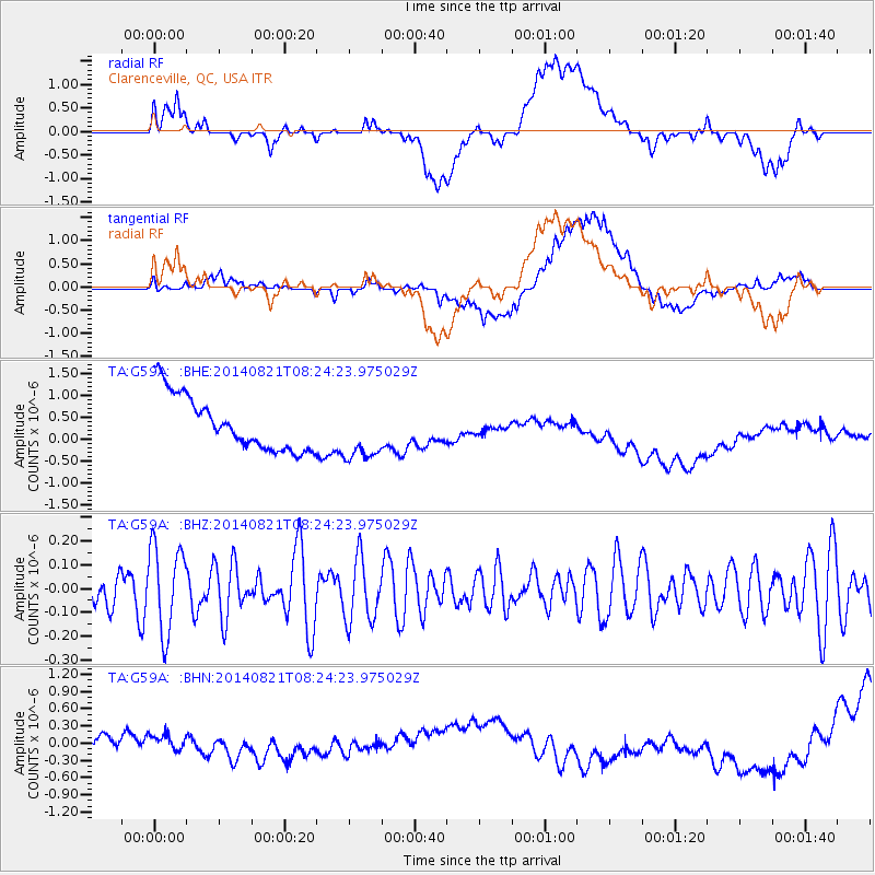
G59A Clarenceville, QC, USA - Earthquake Result Viewer
*The percent match for this event was below the threshold and hence no stack was calculated.
| Earthquake location: |
Kashmir-India Border Region |
| Earthquake latitude/longitude: |
32.3/76.4 |
| Earthquake time(UTC): |
2014/08/21 (233) 08:11:18 GMT |
| Earthquake Depth: |
10 km |
| Earthquake Magnitude: |
4.9 mb |
| Earthquake Catalog/Contributor: |
ISC/ISC |
|
| Network: |
TA USArray Transportable Network (new EarthScope stations) |
| Station: |
G59A Clarenceville, QC, USA |
| Lat/Lon: |
45.08 N/73.18 W |
| Elevation: |
36 m |
|
| Distance: |
98.2 deg |
| Az: |
338.771 deg |
| Baz: |
25.638 deg |
| Ray Param: |
$rayparam |
*The percent match for this event was below the threshold and hence was not used in the summary stack. |
|
| Radial Match: |
16.880482 % |
| Radial Bump: |
400 |
| Transverse Match: |
12.746997 % |
| Transverse Bump: |
400 |
| SOD ConfigId: |
3390531 |
| Insert Time: |
2019-04-13 12:47:25.425 +0000 |
| GWidth: |
2.5 |
| Max Bumps: |
400 |
| Tol: |
0.001 |
|
Signal To Noise
| Channel | StoN | STA | LTA |
| TA:G59A: :BHZ:20140821T08:24:23.975029Z | 2.1347575 | 1.8339986E-7 | 8.591133E-8 |
| TA:G59A: :BHN:20140821T08:24:23.975029Z | 0.6315867 | 1.4128676E-7 | 2.2370132E-7 |
| TA:G59A: :BHE:20140821T08:24:23.975029Z | 1.0804774 | 6.691232E-7 | 6.192848E-7 |
| Arrivals |
| Ps | |
| PpPs | |
| PsPs/PpSs | |


