You are here: Home > Network List > TA - USArray Transportable Network (new EarthScope stations) Stations List
> Station O03E Paynes Creek, CA, USA > Earthquake Result Viewer
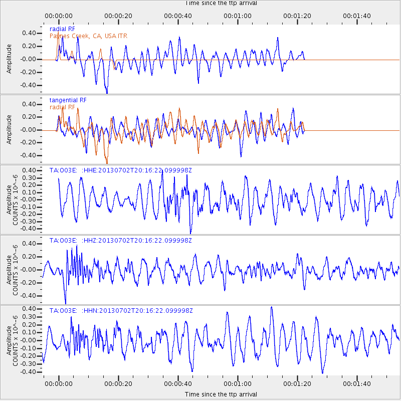
O03E Paynes Creek, CA, USA - Earthquake Result Viewer
*The percent match for this event was below the threshold and hence no stack was calculated.
| Earthquake location: |
Jujuy Province, Argentina |
| Earthquake latitude/longitude: |
-23.9/-66.5 |
| Earthquake time(UTC): |
2013/07/02 (183) 20:04:55 GMT |
| Earthquake Depth: |
199 km |
| Earthquake Magnitude: |
5.6 MW, 5.7 MW |
| Earthquake Catalog/Contributor: |
NEIC PDE/NEIC PDE-W |
|
| Network: |
TA USArray Transportable Network (new EarthScope stations) |
| Station: |
O03E Paynes Creek, CA, USA |
| Lat/Lon: |
40.29 N/121.80 W |
| Elevation: |
967 m |
|
| Distance: |
82.0 deg |
| Az: |
320.583 deg |
| Baz: |
130.528 deg |
| Ray Param: |
$rayparam |
*The percent match for this event was below the threshold and hence was not used in the summary stack. |
|
| Radial Match: |
59.10586 % |
| Radial Bump: |
391 |
| Transverse Match: |
32.851463 % |
| Transverse Bump: |
313 |
| SOD ConfigId: |
512894 |
| Insert Time: |
2013-09-15 12:49:17.825 +0000 |
| GWidth: |
2.5 |
| Max Bumps: |
400 |
| Tol: |
0.001 |
|
Signal To Noise
| Channel | StoN | STA | LTA |
| TA:O03E: :HHZ:20130702T20:16:22.099998Z | 2.5884347 | 1.8841375E-7 | 7.279062E-8 |
| TA:O03E: :HHN:20130702T20:16:22.099998Z | 0.78276825 | 1.10310054E-7 | 1.40923E-7 |
| TA:O03E: :HHE:20130702T20:16:22.099998Z | 1.4846797 | 2.0460105E-7 | 1.3780821E-7 |
| Arrivals |
| Ps | |
| PpPs | |
| PsPs/PpSs | |


