You are here: Home > Network List > TA - USArray Transportable Network (new EarthScope stations) Stations List
> Station S44A Carbondale, IL, USA > Earthquake Result Viewer
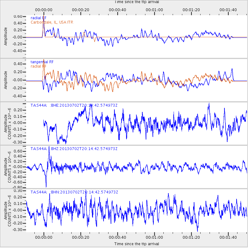
S44A Carbondale, IL, USA - Earthquake Result Viewer
*The percent match for this event was below the threshold and hence no stack was calculated.
| Earthquake location: |
Jujuy Province, Argentina |
| Earthquake latitude/longitude: |
-23.9/-66.5 |
| Earthquake time(UTC): |
2013/07/02 (183) 20:04:55 GMT |
| Earthquake Depth: |
199 km |
| Earthquake Magnitude: |
5.6 MW, 5.7 MW |
| Earthquake Catalog/Contributor: |
NEIC PDE/NEIC PDE-W |
|
| Network: |
TA USArray Transportable Network (new EarthScope stations) |
| Station: |
S44A Carbondale, IL, USA |
| Lat/Lon: |
37.69 N/89.26 W |
| Elevation: |
155 m |
|
| Distance: |
64.8 deg |
| Az: |
340.199 deg |
| Baz: |
156.984 deg |
| Ray Param: |
$rayparam |
*The percent match for this event was below the threshold and hence was not used in the summary stack. |
|
| Radial Match: |
47.783646 % |
| Radial Bump: |
400 |
| Transverse Match: |
45.52367 % |
| Transverse Bump: |
400 |
| SOD ConfigId: |
512894 |
| Insert Time: |
2013-09-15 12:51:48.049 +0000 |
| GWidth: |
2.5 |
| Max Bumps: |
400 |
| Tol: |
0.001 |
|
Signal To Noise
| Channel | StoN | STA | LTA |
| TA:S44A: :BHZ:20130702T20:14:42.574973Z | 5.607365 | 3.051579E-7 | 5.4420905E-8 |
| TA:S44A: :BHN:20130702T20:14:42.574973Z | 1.4601597 | 1.3938258E-7 | 9.545708E-8 |
| TA:S44A: :BHE:20130702T20:14:42.574973Z | 0.69118255 | 1.0401618E-7 | 1.5049017E-7 |
| Arrivals |
| Ps | |
| PpPs | |
| PsPs/PpSs | |


