You are here: Home > Network List > TA - USArray Transportable Network (new EarthScope stations) Stations List
> Station S55A Lewisburg, WV, USA > Earthquake Result Viewer
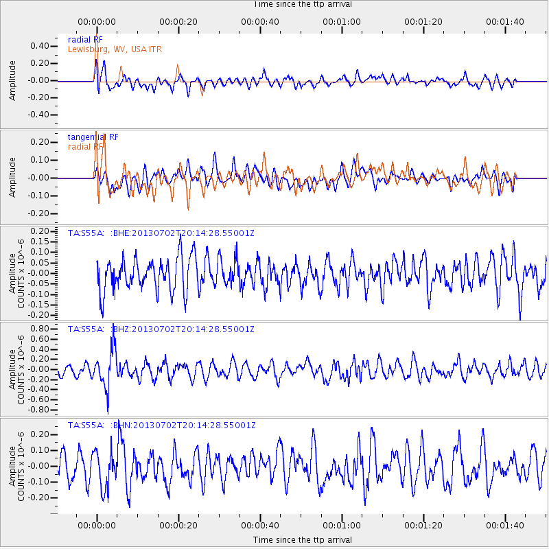
S55A Lewisburg, WV, USA - Earthquake Result Viewer
*The percent match for this event was below the threshold and hence no stack was calculated.
| Earthquake location: |
Jujuy Province, Argentina |
| Earthquake latitude/longitude: |
-23.9/-66.5 |
| Earthquake time(UTC): |
2013/07/02 (183) 20:04:55 GMT |
| Earthquake Depth: |
199 km |
| Earthquake Magnitude: |
5.6 MW, 5.7 MW |
| Earthquake Catalog/Contributor: |
NEIC PDE/NEIC PDE-W |
|
| Network: |
TA USArray Transportable Network (new EarthScope stations) |
| Station: |
S55A Lewisburg, WV, USA |
| Lat/Lon: |
37.77 N/80.50 W |
| Elevation: |
647 m |
|
| Distance: |
62.7 deg |
| Az: |
347.553 deg |
| Baz: |
165.58 deg |
| Ray Param: |
$rayparam |
*The percent match for this event was below the threshold and hence was not used in the summary stack. |
|
| Radial Match: |
59.72661 % |
| Radial Bump: |
400 |
| Transverse Match: |
39.34049 % |
| Transverse Bump: |
400 |
| SOD ConfigId: |
512894 |
| Insert Time: |
2013-09-15 12:52:07.627 +0000 |
| GWidth: |
2.5 |
| Max Bumps: |
400 |
| Tol: |
0.001 |
|
Signal To Noise
| Channel | StoN | STA | LTA |
| TA:S55A: :BHZ:20130702T20:14:28.55001Z | 3.8678272 | 3.8201378E-7 | 9.8767025E-8 |
| TA:S55A: :BHN:20130702T20:14:28.55001Z | 1.3890611 | 1.1607809E-7 | 8.3565865E-8 |
| TA:S55A: :BHE:20130702T20:14:28.55001Z | 0.82015294 | 6.4185E-8 | 7.8259795E-8 |
| Arrivals |
| Ps | |
| PpPs | |
| PsPs/PpSs | |


