You are here: Home > Network List > TA - USArray Transportable Network (new EarthScope stations) Stations List
> Station V46A Holladay, TN, USA > Earthquake Result Viewer
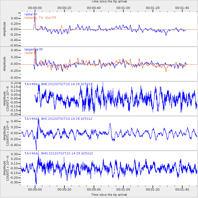
V46A Holladay, TN, USA - Earthquake Result Viewer
*The percent match for this event was below the threshold and hence no stack was calculated.
| Earthquake location: |
Jujuy Province, Argentina |
| Earthquake latitude/longitude: |
-23.9/-66.5 |
| Earthquake time(UTC): |
2013/07/02 (183) 20:04:55 GMT |
| Earthquake Depth: |
199 km |
| Earthquake Magnitude: |
5.6 MW, 5.7 MW |
| Earthquake Catalog/Contributor: |
NEIC PDE/NEIC PDE-W |
|
| Network: |
TA USArray Transportable Network (new EarthScope stations) |
| Station: |
V46A Holladay, TN, USA |
| Lat/Lon: |
35.80 N/88.12 W |
| Elevation: |
162 m |
|
| Distance: |
62.8 deg |
| Az: |
340.328 deg |
| Baz: |
157.719 deg |
| Ray Param: |
$rayparam |
*The percent match for this event was below the threshold and hence was not used in the summary stack. |
|
| Radial Match: |
62.945465 % |
| Radial Bump: |
400 |
| Transverse Match: |
46.778305 % |
| Transverse Bump: |
400 |
| SOD ConfigId: |
512894 |
| Insert Time: |
2013-09-15 12:54:06.736 +0000 |
| GWidth: |
2.5 |
| Max Bumps: |
400 |
| Tol: |
0.001 |
|
Signal To Noise
| Channel | StoN | STA | LTA |
| TA:V46A: :BHZ:20130702T20:14:28.92501Z | 3.8714974 | 2.4875212E-7 | 6.425218E-8 |
| TA:V46A: :BHN:20130702T20:14:28.92501Z | 2.6344218 | 1.4563159E-7 | 5.528028E-8 |
| TA:V46A: :BHE:20130702T20:14:28.92501Z | 1.3201277 | 7.755919E-8 | 5.8751283E-8 |
| Arrivals |
| Ps | |
| PpPs | |
| PsPs/PpSs | |


