You are here: Home > Network List > AK - Alaska Regional Network Stations List
> Station MDM Murphy Dome > Earthquake Result Viewer
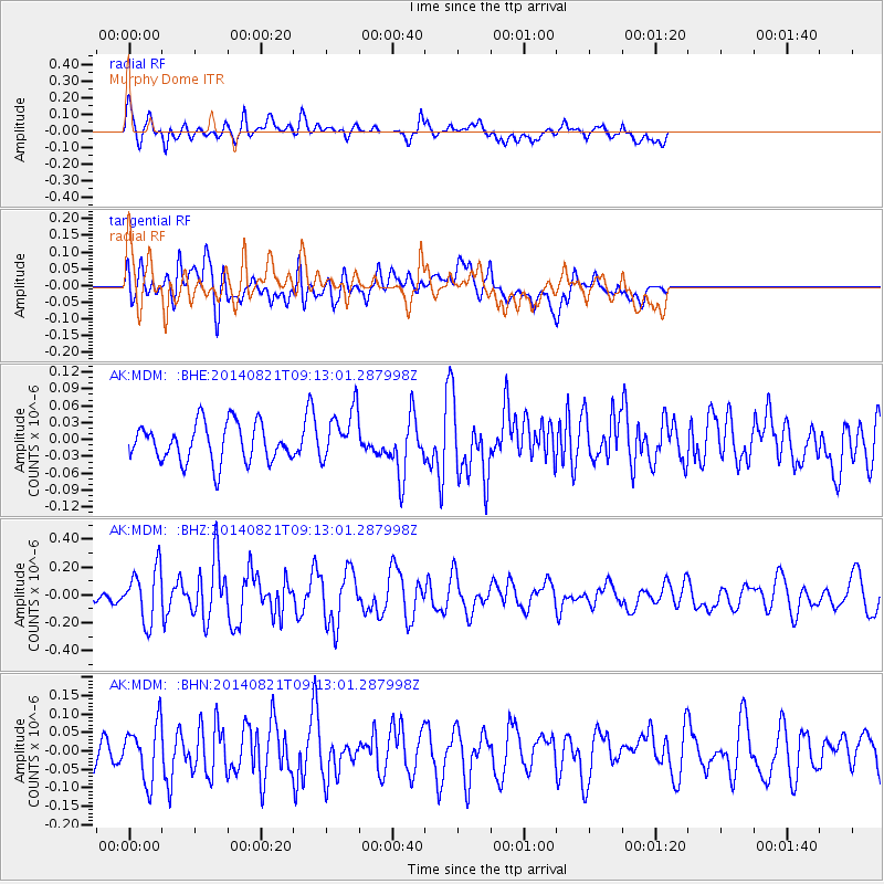
MDM Murphy Dome - Earthquake Result Viewer
*The percent match for this event was below the threshold and hence no stack was calculated.
| Earthquake location: |
Tonga Islands Region |
| Earthquake latitude/longitude: |
-17.6/-172.9 |
| Earthquake time(UTC): |
2014/08/21 (233) 09:01:00 GMT |
| Earthquake Depth: |
10 km |
| Earthquake Magnitude: |
5.3 MW, 5.1 mb |
| Earthquake Catalog/Contributor: |
ISC/ISC |
|
| Network: |
AK Alaska Regional Network |
| Station: |
MDM Murphy Dome |
| Lat/Lon: |
64.96 N/148.23 W |
| Elevation: |
634 m |
|
| Distance: |
84.4 deg |
| Az: |
10.273 deg |
| Baz: |
203.561 deg |
| Ray Param: |
$rayparam |
*The percent match for this event was below the threshold and hence was not used in the summary stack. |
|
| Radial Match: |
76.96437 % |
| Radial Bump: |
400 |
| Transverse Match: |
61.89834 % |
| Transverse Bump: |
400 |
| SOD ConfigId: |
3390531 |
| Insert Time: |
2019-04-13 12:49:29.531 +0000 |
| GWidth: |
2.5 |
| Max Bumps: |
400 |
| Tol: |
0.001 |
|
Signal To Noise
| Channel | StoN | STA | LTA |
| AK:MDM: :BHZ:20140821T09:13:01.287998Z | 3.4019642 | 1.9016774E-7 | 5.5899395E-8 |
| AK:MDM: :BHN:20140821T09:13:01.287998Z | 1.5873276 | 7.550298E-8 | 4.75661E-8 |
| AK:MDM: :BHE:20140821T09:13:01.287998Z | 1.3415687 | 4.5440128E-8 | 3.387089E-8 |
| Arrivals |
| Ps | |
| PpPs | |
| PsPs/PpSs | |


