You are here: Home > Network List > UW - Pacific Northwest Regional Seismic Network Stations List
> Station LTY Liberty (broad-band) > Earthquake Result Viewer
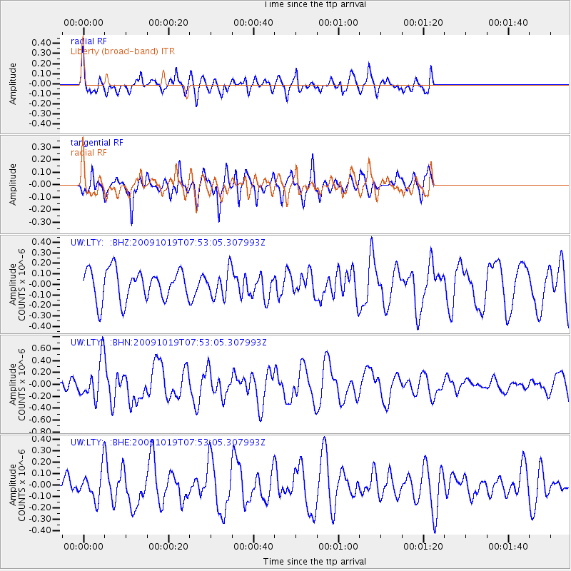
LTY Liberty (broad-band) - Earthquake Result Viewer
*The percent match for this event was below the threshold and hence no stack was calculated.
| Earthquake location: |
Samoa Islands Region |
| Earthquake latitude/longitude: |
-15.4/-173.0 |
| Earthquake time(UTC): |
2009/10/19 (292) 07:41:38 GMT |
| Earthquake Depth: |
10 km |
| Earthquake Magnitude: |
5.8 MW, 5.4 MS, 5.4 MB, 5.8 MW |
| Earthquake Catalog/Contributor: |
WHDF/NEIC |
|
| Network: |
UW Pacific Northwest Regional Seismic Network |
| Station: |
LTY Liberty (broad-band) |
| Lat/Lon: |
47.26 N/120.66 W |
| Elevation: |
970 m |
|
| Distance: |
78.0 deg |
| Az: |
33.442 deg |
| Baz: |
231.28 deg |
| Ray Param: |
$rayparam |
*The percent match for this event was below the threshold and hence was not used in the summary stack. |
|
| Radial Match: |
58.38363 % |
| Radial Bump: |
400 |
| Transverse Match: |
79.35385 % |
| Transverse Bump: |
400 |
| SOD ConfigId: |
2622 |
| Insert Time: |
2010-02-27 04:50:17.878 +0000 |
| GWidth: |
2.5 |
| Max Bumps: |
400 |
| Tol: |
0.001 |
|
Signal To Noise
| Channel | StoN | STA | LTA |
| UW:LTY: :BHN:20091019T07:53:05.307993Z | 4.3186655 | 3.308811E-7 | 7.661652E-8 |
| UW:LTY: :BHE:20091019T07:53:05.307993Z | 1.033763 | 1.3247268E-7 | 1.2814607E-7 |
| UW:LTY: :BHZ:20091019T07:53:05.307993Z | 0.8750905 | 1.2691538E-7 | 1.4503115E-7 |
| Arrivals |
| Ps | |
| PpPs | |
| PsPs/PpSs | |


