You are here: Home > Network List > US - United States National Seismic Network Stations List
> Station BOZ Bozeman, Montana, USA > Earthquake Result Viewer
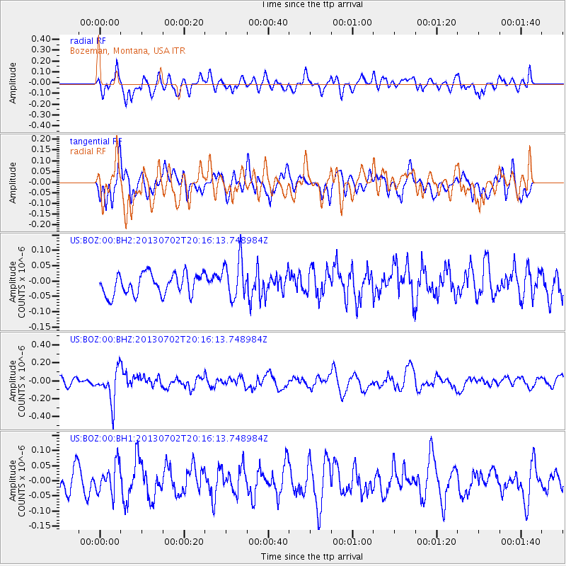
BOZ Bozeman, Montana, USA - Earthquake Result Viewer
*The percent match for this event was below the threshold and hence no stack was calculated.
| Earthquake location: |
Jujuy Province, Argentina |
| Earthquake latitude/longitude: |
-23.9/-66.5 |
| Earthquake time(UTC): |
2013/07/02 (183) 20:04:55 GMT |
| Earthquake Depth: |
199 km |
| Earthquake Magnitude: |
5.6 MW, 5.7 MW |
| Earthquake Catalog/Contributor: |
NEIC PDE/NEIC PDE-W |
|
| Network: |
US United States National Seismic Network |
| Station: |
BOZ Bozeman, Montana, USA |
| Lat/Lon: |
45.65 N/111.63 W |
| Elevation: |
1589 m |
|
| Distance: |
80.4 deg |
| Az: |
329.732 deg |
| Baz: |
138.859 deg |
| Ray Param: |
$rayparam |
*The percent match for this event was below the threshold and hence was not used in the summary stack. |
|
| Radial Match: |
59.312614 % |
| Radial Bump: |
400 |
| Transverse Match: |
49.085434 % |
| Transverse Bump: |
400 |
| SOD ConfigId: |
512894 |
| Insert Time: |
2013-09-15 12:58:02.878 +0000 |
| GWidth: |
2.5 |
| Max Bumps: |
400 |
| Tol: |
0.001 |
|
Signal To Noise
| Channel | StoN | STA | LTA |
| US:BOZ:00:BHZ:20130702T20:16:13.748984Z | 4.335606 | 1.8452903E-7 | 4.25613E-8 |
| US:BOZ:00:BH1:20130702T20:16:13.748984Z | 1.005892 | 4.917165E-8 | 4.8883628E-8 |
| US:BOZ:00:BH2:20130702T20:16:13.748984Z | 1.8624169 | 6.450316E-8 | 3.4634116E-8 |
| Arrivals |
| Ps | |
| PpPs | |
| PsPs/PpSs | |


