You are here: Home > Network List > UW - Pacific Northwest Regional Seismic Network Stations List
> Station MEGW Megler, WA CREST BB SMO > Earthquake Result Viewer
MEGW Megler, WA CREST BB SMO - Earthquake Result Viewer
| Earthquake location: |
Hokkaido, Japan Region |
| Earthquake latitude/longitude: |
43.0/145.1 |
| Earthquake time(UTC): |
2004/11/28 (333) 18:32:14 GMT |
| Earthquake Depth: |
39 km |
| Earthquake Magnitude: |
6.4 MB, 6.7 MS, 7.0 MW, 7.0 MW |
| Earthquake Catalog/Contributor: |
WHDF/NEIC |
|
| Network: |
UW Pacific Northwest Regional Seismic Network |
| Station: |
MEGW Megler, WA CREST BB SMO |
| Lat/Lon: |
46.27 N/123.88 W |
| Elevation: |
332 m |
|
| Distance: |
61.3 deg |
| Az: |
52.274 deg |
| Baz: |
303.242 deg |
| Ray Param: |
0.060903125 |
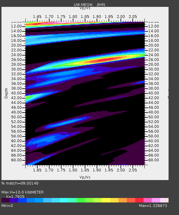
| Estimated Moho Depth: |
10.0 km |
| Estimated Crust Vp/Vs: |
1.79 |
| Assumed Crust Vp: |
6.566 km/s |
| Estimated Crust Vs: |
3.663 km/s |
| Estimated Crust Poisson's Ratio: |
0.27 |
|
| Radial Match: |
89.00148 % |
| Radial Bump: |
400 |
| Transverse Match: |
76.8473 % |
| Transverse Bump: |
400 |
| SOD ConfigId: |
2459 |
| Insert Time: |
2010-02-27 04:50:51.824 +0000 |
| GWidth: |
2.5 |
| Max Bumps: |
400 |
| Tol: |
0.001 |
|
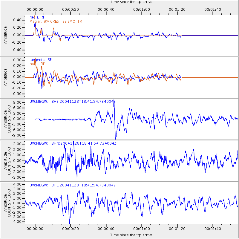
Signal To Noise
| Channel | StoN | STA | LTA |
| UW:MEGW: :BHN:20041128T18:41:54.734004Z | 1.654082 | 557.0585 | 336.77805 |
| UW:MEGW: :BHE:20041128T18:41:54.734004Z | 1.9949352 | 553.1766 | 277.29053 |
| UW:MEGW: :BHZ:20041128T18:41:54.734004Z | 9.929772 | 2067.5117 | 208.21341 |
| Arrivals |
| Ps | 1.3 SECOND |
| PpPs | 4.1 SECOND |
| PsPs/PpSs | 5.3 SECOND |


