You are here: Home > Network List > IC - New China Digital Seismograph Network Stations List
> Station KMI Kunming, Yunnan Province, China > Earthquake Result Viewer
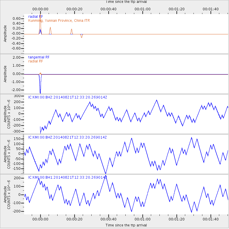
KMI Kunming, Yunnan Province, China - Earthquake Result Viewer
| Earthquake location: |
Talaud Islands, Indonesia |
| Earthquake latitude/longitude: |
3.0/126.0 |
| Earthquake time(UTC): |
2014/08/21 (233) 12:27:42 GMT |
| Earthquake Depth: |
132 km |
| Earthquake Magnitude: |
4.9 MW, 4.8 mb |
| Earthquake Catalog/Contributor: |
ISC/ISC |
|
| Network: |
IC New China Digital Seismograph Network |
| Station: |
KMI Kunming, Yunnan Province, China |
| Lat/Lon: |
25.12 N/102.74 E |
| Elevation: |
1975 m |
|
| Distance: |
31.4 deg |
| Az: |
316.691 deg |
| Baz: |
130.913 deg |
| Ray Param: |
0.07872552 |
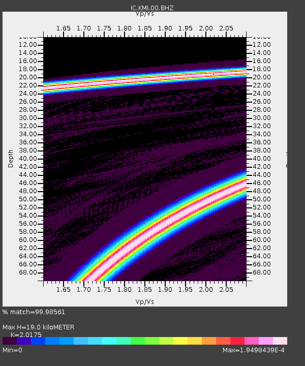
| Estimated Moho Depth: |
19.0 km |
| Estimated Crust Vp/Vs: |
2.02 |
| Assumed Crust Vp: |
6.247 km/s |
| Estimated Crust Vs: |
3.096 km/s |
| Estimated Crust Poisson's Ratio: |
0.34 |
|
| Radial Match: |
99.98561 % |
| Radial Bump: |
4 |
| Transverse Match: |
99.9934 % |
| Transverse Bump: |
2 |
| SOD ConfigId: |
3390531 |
| Insert Time: |
2019-04-13 12:57:18.780 +0000 |
| GWidth: |
2.5 |
| Max Bumps: |
400 |
| Tol: |
0.001 |
|
Signal To Noise
| Channel | StoN | STA | LTA |
| IC:KMI:00:BHZ:20140821T12:33:20.269014Z | 2.250244 | 1.6704538E-4 | 7.423435E-5 |
| IC:KMI:00:BH1:20140821T12:33:20.269014Z | 2.2581236 | 2.0265451E-4 | 8.974465E-5 |
| IC:KMI:00:BH2:20140821T12:33:20.269014Z | 2.2568226 | 2.0289904E-4 | 8.990474E-5 |
| Arrivals |
| Ps | 3.3 SECOND |
| PpPs | 8.6 SECOND |
| PsPs/PpSs | 12 SECOND |


