You are here: Home > Network List > UW - Pacific Northwest Regional Seismic Network Stations List
> Station MEGW Megler, WA CREST BB SMO > Earthquake Result Viewer
MEGW Megler, WA CREST BB SMO - Earthquake Result Viewer
| Earthquake location: |
Chile-Bolivia Border Region |
| Earthquake latitude/longitude: |
-22.3/-67.9 |
| Earthquake time(UTC): |
2005/11/17 (321) 19:26:56 GMT |
| Earthquake Depth: |
163 km |
| Earthquake Magnitude: |
6.0 MB, 6.9 MW, 6.8 MW |
| Earthquake Catalog/Contributor: |
WHDF/NEIC |
|
| Network: |
UW Pacific Northwest Regional Seismic Network |
| Station: |
MEGW Megler, WA CREST BB SMO |
| Lat/Lon: |
46.27 N/123.88 W |
| Elevation: |
332 m |
|
| Distance: |
85.0 deg |
| Az: |
324.741 deg |
| Baz: |
129.599 deg |
| Ray Param: |
0.044710442 |
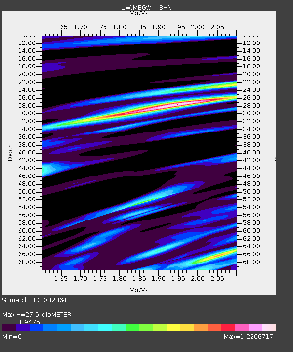
| Estimated Moho Depth: |
27.5 km |
| Estimated Crust Vp/Vs: |
1.95 |
| Assumed Crust Vp: |
6.566 km/s |
| Estimated Crust Vs: |
3.372 km/s |
| Estimated Crust Poisson's Ratio: |
0.32 |
|
| Radial Match: |
83.032364 % |
| Radial Bump: |
342 |
| Transverse Match: |
67.3317 % |
| Transverse Bump: |
400 |
| SOD ConfigId: |
2564 |
| Insert Time: |
2010-02-27 04:50:58.807 +0000 |
| GWidth: |
2.5 |
| Max Bumps: |
400 |
| Tol: |
0.001 |
|

Signal To Noise
| Channel | StoN | STA | LTA |
| UW:MEGW: :BHN:20051117T19:38:42.271003Z | 4.7662735 | 2.22847E-6 | 4.6754977E-7 |
| UW:MEGW: :BHE:20051117T19:38:42.271003Z | 1.7519193 | 1.2332837E-6 | 7.0396146E-7 |
| UW:MEGW: :BHZ:20051117T19:38:42.271003Z | 15.975809 | 5.071442E-6 | 3.1744509E-7 |
| Arrivals |
| Ps | 4.1 SECOND |
| PpPs | 12 SECOND |
| PsPs/PpSs | 16 SECOND |


