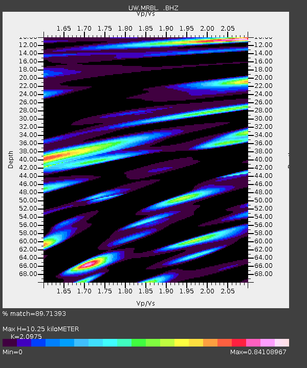
MRBL Marblemount, WA, USA - Earthquake Result Viewer
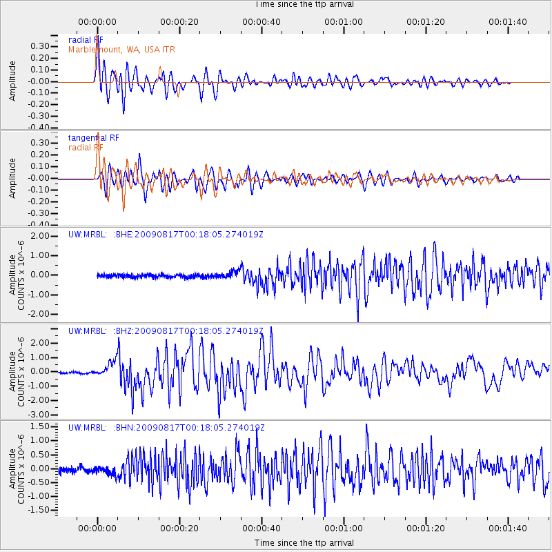
Earthquake location: Southwestern Ryukyu Isl., Japan
Earthquake latitude/longitude: 23.5/123.5
Earthquake time(UTC): 2009/08/17 (229) 00:05:49 GMT
Earthquake Depth: 20 km
Earthquake Magnitude: 6.2 MB, 6.6 MS, 6.7 MW, 6.6 MW
Earthquake Catalog/Contributor: WHDF/NEIC
Network: UW Pacific Northwest Regional Seismic Network
Station: MRBL Marblemount, WA, USA
Lat/Lon: 48.52 N/121.48 W
Elevation: 75 m
Distance: 87.8 deg
Az: 37.081 deg
Baz: 303.643 deg
Ray Param: 0.043029808
Estimated Moho Depth: 10.25 km
Estimated Crust Vp/Vs: 2.10
Assumed Crust Vp: 6.566 km/s
Estimated Crust Vs: 3.13 km/s
Estimated Crust Poisson's Ratio: 0.35
Radial Match: 89.71393 %
Radial Bump: 400
Transverse Match: 92.460625 %
Transverse Bump: 400
SOD ConfigId: 2622
Insert Time: 2010-02-27 04:51:34.656 +0000
GWidth: 2.5
Max Bumps: 400
Tol: 0.001

Signal To Noise

ChannelStoNSTALTA
UW:MRBL: :BHZ:20090817T00:18:05.274019Z10.3984935.6635173E-75.4464792E-8
UW:MRBL: :BHN:20090817T00:18:05.274019Z1.87324771.431675E-77.6427426E-8
UW:MRBL: :BHE:20090817T00:18:05.274019Z2.45373821.8700159E-77.62109E-8
Arrivals
Ps1.7 SECOND
PpPs4.7 SECOND
PsPs/PpSs6.5 SECOND