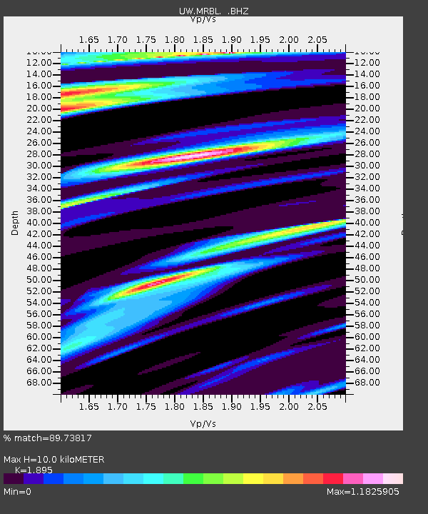
MRBL Marblemount, WA, USA - Earthquake Result Viewer
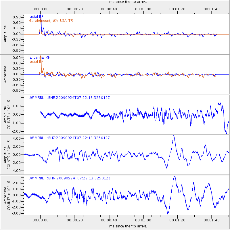
Earthquake location: Off Coast Of Jalisco, Mexico
Earthquake latitude/longitude: 18.8/-107.3
Earthquake time(UTC): 2009/09/24 (267) 07:16:19 GMT
Earthquake Depth: 10 km
Earthquake Magnitude: 5.8 MB, 6.2 MS, 6.3 MW, 6.3 MW
Earthquake Catalog/Contributor: WHDF/NEIC
Network: UW Pacific Northwest Regional Seismic Network
Station: MRBL Marblemount, WA, USA
Lat/Lon: 48.52 N/121.48 W
Elevation: 75 m
Distance: 31.8 deg
Az: 342.029 deg
Baz: 153.926 deg
Ray Param: 0.07893828
Estimated Moho Depth: 10.0 km
Estimated Crust Vp/Vs: 1.89
Assumed Crust Vp: 6.566 km/s
Estimated Crust Vs: 3.465 km/s
Estimated Crust Poisson's Ratio: 0.31
Radial Match: 89.73817 %
Radial Bump: 371
Transverse Match: 66.39214 %
Transverse Bump: 400
SOD ConfigId: 2622
Insert Time: 2010-02-27 04:51:39.832 +0000
GWidth: 2.5
Max Bumps: 400
Tol: 0.001

Signal To Noise

ChannelStoNSTALTA
UW:MRBL: :BHZ:20090924T07:22:13.325012Z4.7127141.0609363E-62.2512212E-7
UW:MRBL: :BHN:20090924T07:22:13.325012Z2.55919865.9362185E-72.3195615E-7
UW:MRBL: :BHE:20090924T07:22:13.325012Z2.32240583.6552953E-71.573926E-7
Arrivals
Ps1.5 SECOND
PpPs4.1 SECOND
PsPs/PpSs5.6 SECOND