You are here: Home > Network List > UW - Pacific Northwest Regional Seismic Network Stations List
> Station MRBL Marblemount, WA, USA > Earthquake Result Viewer
MRBL Marblemount, WA, USA - Earthquake Result Viewer
| Earthquake location: |
Tonga Islands |
| Earthquake latitude/longitude: |
-16.3/-173.5 |
| Earthquake time(UTC): |
2009/10/02 (275) 01:07:39 GMT |
| Earthquake Depth: |
8.0 km |
| Earthquake Magnitude: |
6.1 MB, 6.0 MS, 6.1 MW, 6.1 MW |
| Earthquake Catalog/Contributor: |
WHDF/NEIC |
|
| Network: |
UW Pacific Northwest Regional Seismic Network |
| Station: |
MRBL Marblemount, WA, USA |
| Lat/Lon: |
48.52 N/121.48 W |
| Elevation: |
75 m |
|
| Distance: |
79.4 deg |
| Az: |
32.206 deg |
| Baz: |
230.323 deg |
| Ray Param: |
0.04900661 |
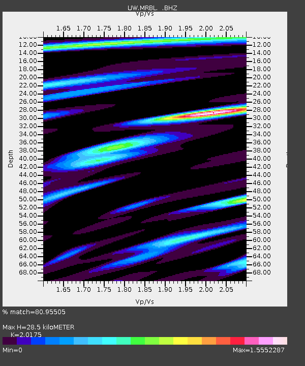
| Estimated Moho Depth: |
28.5 km |
| Estimated Crust Vp/Vs: |
2.02 |
| Assumed Crust Vp: |
6.566 km/s |
| Estimated Crust Vs: |
3.255 km/s |
| Estimated Crust Poisson's Ratio: |
0.34 |
|
| Radial Match: |
80.95505 % |
| Radial Bump: |
400 |
| Transverse Match: |
67.112236 % |
| Transverse Bump: |
400 |
| SOD ConfigId: |
2622 |
| Insert Time: |
2010-02-27 04:51:41.268 +0000 |
| GWidth: |
2.5 |
| Max Bumps: |
400 |
| Tol: |
0.001 |
|
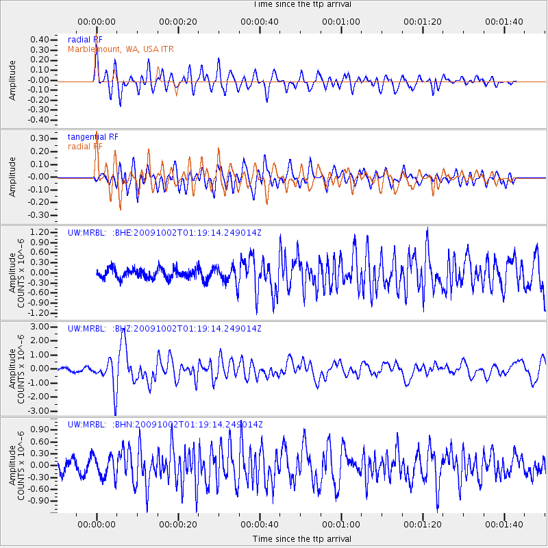
Signal To Noise
| Channel | StoN | STA | LTA |
| UW:MRBL: :BHZ:20091002T01:19:14.249014Z | 6.749764 | 1.0611235E-6 | 1.5720897E-7 |
| UW:MRBL: :BHN:20091002T01:19:14.249014Z | 1.9490011 | 2.689504E-7 | 1.3799398E-7 |
| UW:MRBL: :BHE:20091002T01:19:14.249014Z | 1.9682796 | 2.6640356E-7 | 1.3534843E-7 |
| Arrivals |
| Ps | 4.5 SECOND |
| PpPs | 13 SECOND |
| PsPs/PpSs | 17 SECOND |


