You are here: Home > Network List > UW - Pacific Northwest Regional Seismic Network Stations List
> Station MRBL Marblemount, WA, USA > Earthquake Result Viewer
MRBL Marblemount, WA, USA - Earthquake Result Viewer
| Earthquake location: |
Ryukyu Islands, Japan |
| Earthquake latitude/longitude: |
29.2/129.8 |
| Earthquake time(UTC): |
2009/10/30 (303) 07:03:39 GMT |
| Earthquake Depth: |
34 km |
| Earthquake Magnitude: |
6.3 MB, 6.8 MS, 6.8 MW, 6.8 MW |
| Earthquake Catalog/Contributor: |
WHDF/NEIC |
|
| Network: |
UW Pacific Northwest Regional Seismic Network |
| Station: |
MRBL Marblemount, WA, USA |
| Lat/Lon: |
48.52 N/121.48 W |
| Elevation: |
75 m |
|
| Distance: |
79.9 deg |
| Az: |
39.765 deg |
| Baz: |
302.755 deg |
| Ray Param: |
0.04862581 |
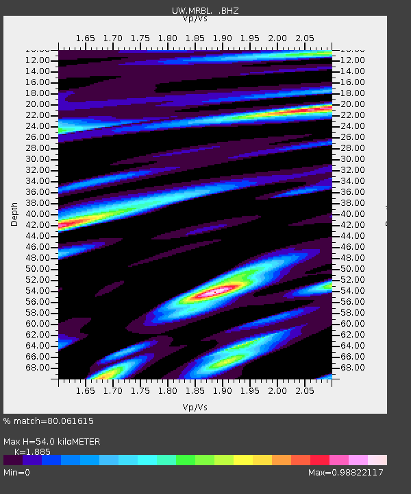
| Estimated Moho Depth: |
54.0 km |
| Estimated Crust Vp/Vs: |
1.88 |
| Assumed Crust Vp: |
6.566 km/s |
| Estimated Crust Vs: |
3.483 km/s |
| Estimated Crust Poisson's Ratio: |
0.30 |
|
| Radial Match: |
80.061615 % |
| Radial Bump: |
400 |
| Transverse Match: |
76.700615 % |
| Transverse Bump: |
400 |
| SOD ConfigId: |
2622 |
| Insert Time: |
2010-02-27 04:51:47.149 +0000 |
| GWidth: |
2.5 |
| Max Bumps: |
400 |
| Tol: |
0.001 |
|
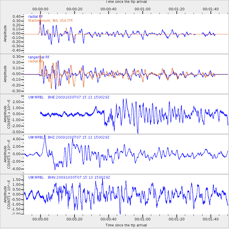
Signal To Noise
| Channel | StoN | STA | LTA |
| UW:MRBL: :BHZ:20091030T07:15:13.150029Z | 8.852901 | 2.122007E-6 | 2.396962E-7 |
| UW:MRBL: :BHN:20091030T07:15:13.150029Z | 1.2425154 | 3.8804384E-7 | 3.1230508E-7 |
| UW:MRBL: :BHE:20091030T07:15:13.150029Z | 3.4637651 | 6.077958E-7 | 1.7547258E-7 |
| Arrivals |
| Ps | 7.5 SECOND |
| PpPs | 23 SECOND |
| PsPs/PpSs | 31 SECOND |


