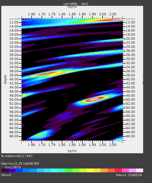
MRBL Marblemount, WA, USA - Earthquake Result Viewer
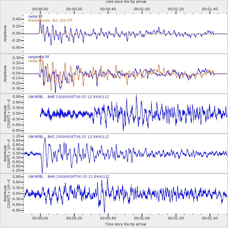
Earthquake location: Near East Coast Of Honshu, Japan
Earthquake latitude/longitude: 35.5/140.9
Earthquake time(UTC): 2009/06/06 (157) 05:52:43 GMT
Earthquake Depth: 34 km
Earthquake Magnitude: 5.8 MB, 5.4 MS, 5.8 MW, 5.7 MW
Earthquake Catalog/Contributor: WHDF/NEIC
Network: UW Pacific Northwest Regional Seismic Network
Station: MRBL Marblemount, WA, USA
Lat/Lon: 48.52 N/121.48 W
Elevation: 75 m
Distance: 68.9 deg
Az: 44.939 deg
Baz: 299.883 deg
Ray Param: 0.05594366
Estimated Moho Depth: 10.25 km
Estimated Crust Vp/Vs: 2.10
Assumed Crust Vp: 6.566 km/s
Estimated Crust Vs: 3.13 km/s
Estimated Crust Poisson's Ratio: 0.35
Radial Match: 83.17487 %
Radial Bump: 400
Transverse Match: 83.73708 %
Transverse Bump: 400
SOD ConfigId: 2648
Insert Time: 2010-02-27 04:51:59.441 +0000
GWidth: 2.5
Max Bumps: 400
Tol: 0.001

Signal To Noise

ChannelStoNSTALTA
UW:MRBL: :BHZ:20090606T06:03:13.849011Z11.4736816.4021725E-75.5798765E-8
UW:MRBL: :BHN:20090606T06:03:13.849011Z1.61832071.8915873E-71.1688581E-7
UW:MRBL: :BHE:20090606T06:03:13.849011Z1.65112461.966027E-71.1907199E-7
Arrivals
Ps1.8 SECOND
PpPs4.7 SECOND
PsPs/PpSs6.4 SECOND