You are here: Home > Network List > TA - USArray Transportable Network (new EarthScope stations) Stations List
> Station E47A Iron Bridge, ON, CAN > Earthquake Result Viewer
E47A Iron Bridge, ON, CAN - Earthquake Result Viewer
| Earthquake location: |
Fox Islands, Aleutian Islands |
| Earthquake latitude/longitude: |
51.6/-167.0 |
| Earthquake time(UTC): |
2013/07/03 (184) 03:40:27 GMT |
| Earthquake Depth: |
5.1 km |
| Earthquake Magnitude: |
5.8 MW, 5.7 MW, 5.9 MB |
| Earthquake Catalog/Contributor: |
NEIC PDE/NEIC PDE-W |
|
| Network: |
TA USArray Transportable Network (new EarthScope stations) |
| Station: |
E47A Iron Bridge, ON, CAN |
| Lat/Lon: |
46.45 N/83.28 W |
| Elevation: |
246 m |
|
| Distance: |
52.3 deg |
| Az: |
60.33 deg |
| Baz: |
308.412 deg |
| Ray Param: |
0.06687718 |
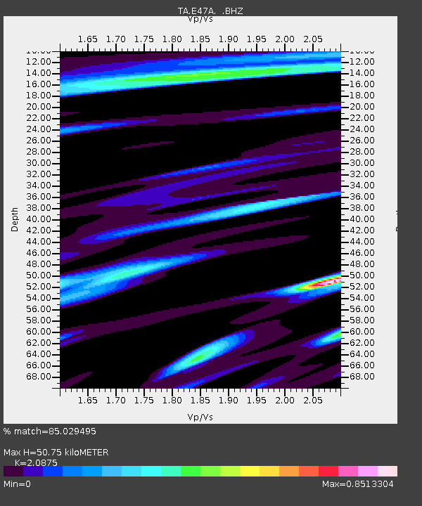
| Estimated Moho Depth: |
50.75 km |
| Estimated Crust Vp/Vs: |
2.09 |
| Assumed Crust Vp: |
6.467 km/s |
| Estimated Crust Vs: |
3.098 km/s |
| Estimated Crust Poisson's Ratio: |
0.35 |
|
| Radial Match: |
85.029495 % |
| Radial Bump: |
400 |
| Transverse Match: |
70.76207 % |
| Transverse Bump: |
400 |
| SOD ConfigId: |
512894 |
| Insert Time: |
2013-09-15 13:35:32.508 +0000 |
| GWidth: |
2.5 |
| Max Bumps: |
400 |
| Tol: |
0.001 |
|

Signal To Noise
| Channel | StoN | STA | LTA |
| TA:E47A: :BHZ:20130703T03:49:08.225017Z | 7.4818134 | 8.1644953E-7 | 1.0912455E-7 |
| TA:E47A: :BHN:20130703T03:49:08.225017Z | 4.6414766 | 2.7448553E-7 | 5.913754E-8 |
| TA:E47A: :BHE:20130703T03:49:08.225017Z | 4.924066 | 3.4070175E-7 | 6.919114E-8 |
| Arrivals |
| Ps | 9.0 SECOND |
| PpPs | 23 SECOND |
| PsPs/PpSs | 32 SECOND |


