You are here: Home > Network List > TA - USArray Transportable Network (new EarthScope stations) Stations List
> Station E48A Lockeyer, ON, CAN > Earthquake Result Viewer
E48A Lockeyer, ON, CAN - Earthquake Result Viewer
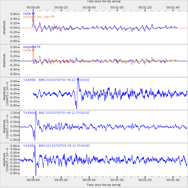
| Earthquake location: |
Fox Islands, Aleutian Islands |
| Earthquake latitude/longitude: |
51.6/-167.0 |
| Earthquake time(UTC): |
2013/07/03 (184) 03:40:27 GMT |
| Earthquake Depth: |
5.1 km |
| Earthquake Magnitude: |
5.8 MW, 5.7 MW, 5.9 MB |
| Earthquake Catalog/Contributor: |
NEIC PDE/NEIC PDE-W |
|
| Network: |
TA USArray Transportable Network (new EarthScope stations) |
| Station: |
E48A Lockeyer, ON, CAN |
| Lat/Lon: |
46.48 N/82.17 W |
| Elevation: |
347 m |
|
| Distance: |
52.9 deg |
| Az: |
59.7 deg |
| Baz: |
308.833 deg |
| Ray Param: |
0.06650203 |
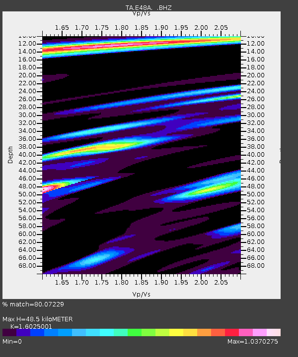
| Estimated Moho Depth: |
48.5 km |
| Estimated Crust Vp/Vs: |
1.60 |
| Assumed Crust Vp: |
6.467 km/s |
| Estimated Crust Vs: |
4.035 km/s |
| Estimated Crust Poisson's Ratio: |
0.18 |
|
| Radial Match: |
80.07229 % |
| Radial Bump: |
400 |
| Transverse Match: |
62.39013 % |
| Transverse Bump: |
400 |
| SOD ConfigId: |
512894 |
| Insert Time: |
2013-09-15 13:35:38.129 +0000 |
| GWidth: |
2.5 |
| Max Bumps: |
400 |
| Tol: |
0.001 |
|
Signal To Noise
| Channel | StoN | STA | LTA |
| TA:E48A: :BHZ:20130703T03:49:12.550029Z | 9.041973 | 7.916535E-7 | 8.755318E-8 |
| TA:E48A: :BHN:20130703T03:49:12.550029Z | 6.705703 | 3.750864E-7 | 5.593543E-8 |
| TA:E48A: :BHE:20130703T03:49:12.550029Z | 5.4322257 | 4.0283743E-7 | 7.415697E-8 |
| Arrivals |
| Ps | 4.8 SECOND |
| PpPs | 18 SECOND |
| PsPs/PpSs | 23 SECOND |


