You are here: Home > Network List > UW - Pacific Northwest Regional Seismic Network Stations List
> Station MRBL Marblemount, WA, USA > Earthquake Result Viewer
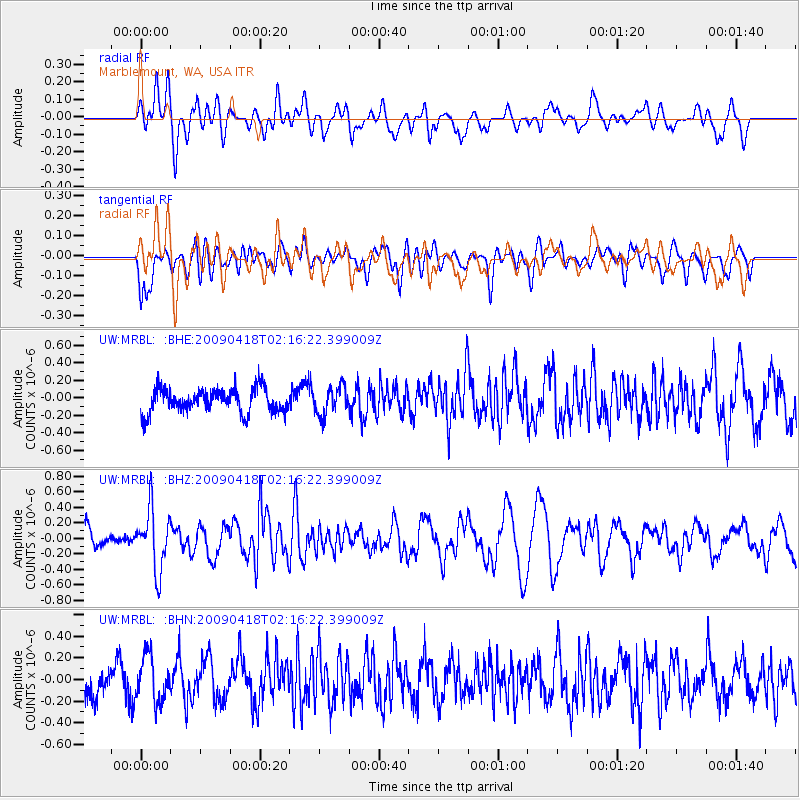
MRBL Marblemount, WA, USA - Earthquake Result Viewer
*The percent match for this event was below the threshold and hence no stack was calculated.
| Earthquake location: |
Kermadec Islands Region |
| Earthquake latitude/longitude: |
-28.9/-177.4 |
| Earthquake time(UTC): |
2009/04/18 (108) 02:03:52 GMT |
| Earthquake Depth: |
65 km |
| Earthquake Magnitude: |
6.0 MB, 5.8 MW, 5.7 MW |
| Earthquake Catalog/Contributor: |
WHDF/NEIC |
|
| Network: |
UW Pacific Northwest Regional Seismic Network |
| Station: |
MRBL Marblemount, WA, USA |
| Lat/Lon: |
48.52 N/121.48 W |
| Elevation: |
75 m |
|
| Distance: |
91.9 deg |
| Az: |
33.453 deg |
| Baz: |
226.626 deg |
| Ray Param: |
$rayparam |
*The percent match for this event was below the threshold and hence was not used in the summary stack. |
|
| Radial Match: |
62.45794 % |
| Radial Bump: |
400 |
| Transverse Match: |
48.850655 % |
| Transverse Bump: |
400 |
| SOD ConfigId: |
2760 |
| Insert Time: |
2010-02-27 04:52:13.717 +0000 |
| GWidth: |
2.5 |
| Max Bumps: |
400 |
| Tol: |
0.001 |
|
Signal To Noise
| Channel | StoN | STA | LTA |
| UW:MRBL: :BHZ:20090418T02:16:22.399009Z | 2.6902173 | 3.8700585E-7 | 1.4385674E-7 |
| UW:MRBL: :BHN:20090418T02:16:22.399009Z | 1.167385 | 2.0357581E-7 | 1.7438619E-7 |
| UW:MRBL: :BHE:20090418T02:16:22.399009Z | 1.1670586 | 1.588899E-7 | 1.3614562E-7 |
| Arrivals |
| Ps | |
| PpPs | |
| PsPs/PpSs | |


