You are here: Home > Network List > TA - USArray Transportable Network (new EarthScope stations) Stations List
> Station H47A Mio, MI, USA > Earthquake Result Viewer
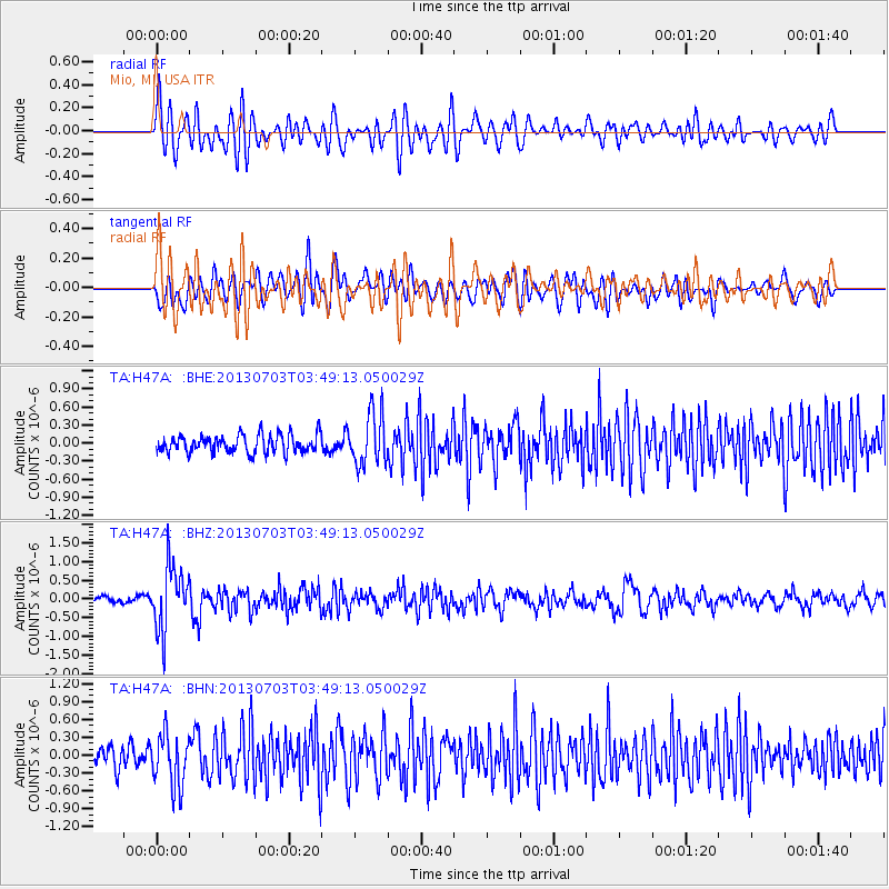
H47A Mio, MI, USA - Earthquake Result Viewer
*The percent match for this event was below the threshold and hence no stack was calculated.
| Earthquake location: |
Fox Islands, Aleutian Islands |
| Earthquake latitude/longitude: |
51.6/-167.0 |
| Earthquake time(UTC): |
2013/07/03 (184) 03:40:27 GMT |
| Earthquake Depth: |
5.1 km |
| Earthquake Magnitude: |
5.8 MW, 5.7 MW, 5.9 MB |
| Earthquake Catalog/Contributor: |
NEIC PDE/NEIC PDE-W |
|
| Network: |
TA USArray Transportable Network (new EarthScope stations) |
| Station: |
H47A Mio, MI, USA |
| Lat/Lon: |
44.60 N/84.21 W |
| Elevation: |
356 m |
|
| Distance: |
52.9 deg |
| Az: |
62.665 deg |
| Baz: |
309.17 deg |
| Ray Param: |
$rayparam |
*The percent match for this event was below the threshold and hence was not used in the summary stack. |
|
| Radial Match: |
59.45695 % |
| Radial Bump: |
400 |
| Transverse Match: |
54.07444 % |
| Transverse Bump: |
400 |
| SOD ConfigId: |
512894 |
| Insert Time: |
2013-09-15 13:37:15.952 +0000 |
| GWidth: |
2.5 |
| Max Bumps: |
400 |
| Tol: |
0.001 |
|
Signal To Noise
| Channel | StoN | STA | LTA |
| TA:H47A: :BHZ:20130703T03:49:13.050029Z | 5.8511186 | 8.50575E-7 | 1.4536964E-7 |
| TA:H47A: :BHN:20130703T03:49:13.050029Z | 2.1190288 | 4.2739993E-7 | 2.0169614E-7 |
| TA:H47A: :BHE:20130703T03:49:13.050029Z | 2.8985775 | 4.3401934E-7 | 1.4973529E-7 |
| Arrivals |
| Ps | |
| PpPs | |
| PsPs/PpSs | |


