You are here: Home > Network List > UW - Pacific Northwest Regional Seismic Network Stations List
> Station MRBL Marblemount, WA, USA > Earthquake Result Viewer
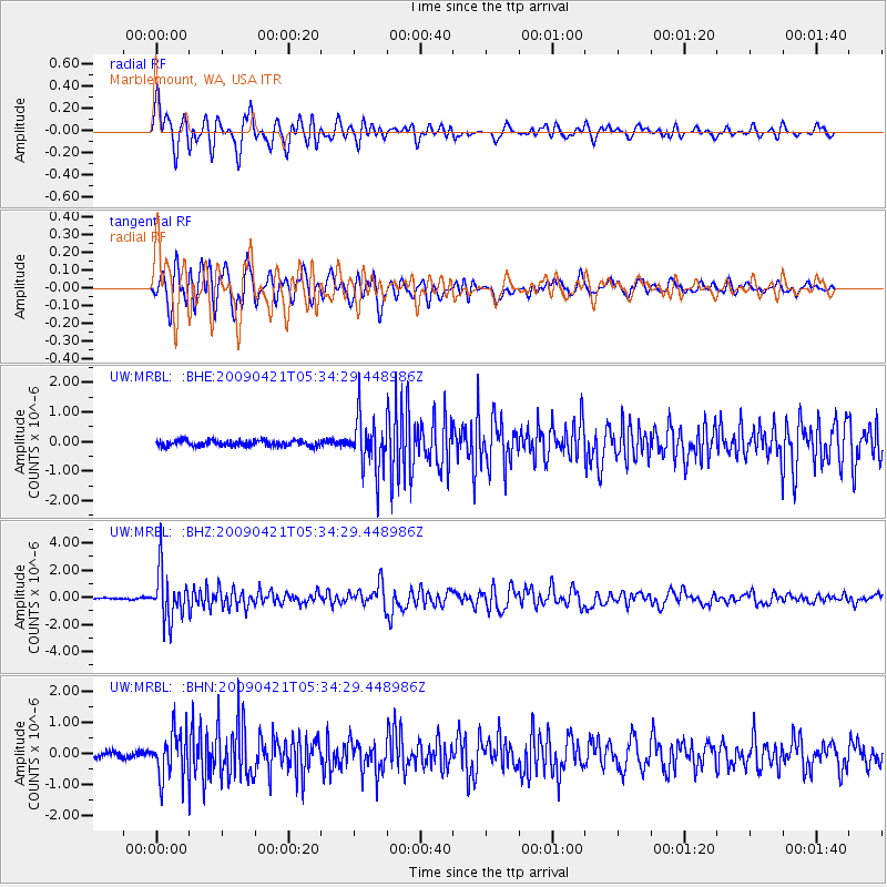
MRBL Marblemount, WA, USA - Earthquake Result Viewer
*The percent match for this event was below the threshold and hence no stack was calculated.
| Earthquake location: |
Kuril Islands |
| Earthquake latitude/longitude: |
50.8/155.0 |
| Earthquake time(UTC): |
2009/04/21 (111) 05:26:11 GMT |
| Earthquake Depth: |
152 km |
| Earthquake Magnitude: |
6.0 MB, 6.2 MW, 6.2 MW |
| Earthquake Catalog/Contributor: |
WHDF/NEIC |
|
| Network: |
UW Pacific Northwest Regional Seismic Network |
| Station: |
MRBL Marblemount, WA, USA |
| Lat/Lon: |
48.52 N/121.48 W |
| Elevation: |
75 m |
|
| Distance: |
51.3 deg |
| Az: |
57.83 deg |
| Baz: |
306.164 deg |
| Ray Param: |
$rayparam |
*The percent match for this event was below the threshold and hence was not used in the summary stack. |
|
| Radial Match: |
76.42363 % |
| Radial Bump: |
400 |
| Transverse Match: |
77.33017 % |
| Transverse Bump: |
400 |
| SOD ConfigId: |
2760 |
| Insert Time: |
2010-02-27 04:52:20.280 +0000 |
| GWidth: |
2.5 |
| Max Bumps: |
400 |
| Tol: |
0.001 |
|
Signal To Noise
| Channel | StoN | STA | LTA |
| UW:MRBL: :BHZ:20090421T05:34:29.448986Z | 17.172964 | 1.7588214E-6 | 1.0241805E-7 |
| UW:MRBL: :BHN:20090421T05:34:29.448986Z | 3.6556454 | 7.4724755E-7 | 2.0440922E-7 |
| UW:MRBL: :BHE:20090421T05:34:29.448986Z | 8.993742 | 8.622349E-7 | 9.587054E-8 |
| Arrivals |
| Ps | |
| PpPs | |
| PsPs/PpSs | |


